You are here: Home > Network List > TA - USArray Transportable Network (new EarthScope stations) Stations List
> Station Q58A Fox Den Farm, The Plains, VA, USA > Earthquake Result Viewer
Q58A Fox Den Farm, The Plains, VA, USA - Earthquake Result Viewer
| Earthquake location: |
Northern Alaska |
| Earthquake latitude/longitude: |
67.9/-162.4 |
| Earthquake time(UTC): |
2014/06/07 (158) 04:43:34 GMT |
| Earthquake Depth: |
14 km |
| Earthquake Magnitude: |
6.0 MI |
| Earthquake Catalog/Contributor: |
NEIC PDE/NEIC ALERT |
|
| Network: |
TA USArray Transportable Network (new EarthScope stations) |
| Station: |
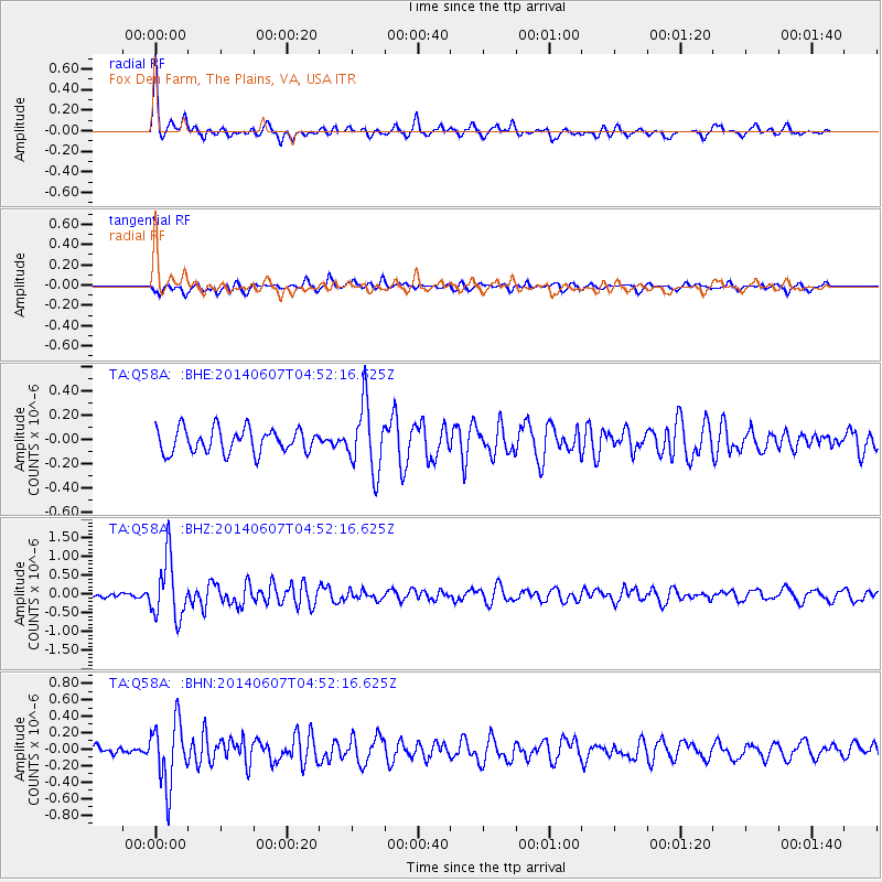
Q58A Fox Den Farm, The Plains, VA, USA |
| Lat/Lon: |
38.94 N/77.68 W |
| Elevation: |
182 m |
|
| Distance: |
52.7 deg |
| Az: |
77.63 deg |
| Baz: |
331.686 deg |
| Ray Param: |
0.066613525 |
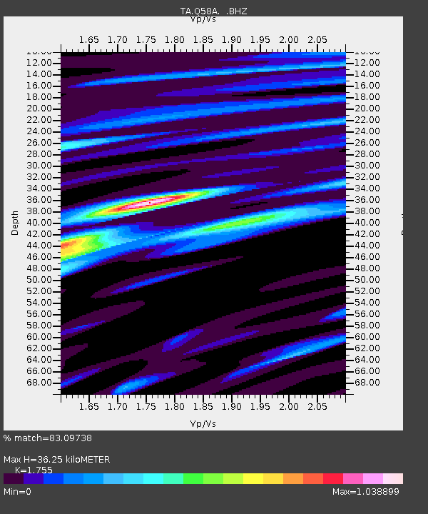
| Estimated Moho Depth: |
36.25 km |
| Estimated Crust Vp/Vs: |
1.75 |
| Assumed Crust Vp: |
6.419 km/s |
| Estimated Crust Vs: |
3.658 km/s |
| Estimated Crust Poisson's Ratio: |
0.26 |
|
| Radial Match: |
83.09738 % |
| Radial Bump: |
319 |
| Transverse Match: |
58.56203 % |
| Transverse Bump: |
400 |
| SOD ConfigId: |
626651 |
| Insert Time: |
2014-06-21 05:44:38.063 +0000 |
| GWidth: |
2.5 |
| Max Bumps: |
400 |
| Tol: |
0.001 |
|
Signal To Noise
| Channel | StoN | STA | LTA |
| TA:Q58A: :BHZ:20140607T04:52:16.625Z | 12.3822775 | 7.942875E-7 | 6.414712E-8 |
| TA:Q58A: :BHN:20140607T04:52:16.625Z | 6.879452 | 3.8515086E-7 | 5.598569E-8 |
| TA:Q58A: :BHE:20140607T04:52:16.625Z | 2.7853162 | 2.7273774E-7 | 9.7919845E-8 |
| Arrivals |
| Ps | 4.5 SECOND |
| PpPs | 15 SECOND |
| PsPs/PpSs | 19 SECOND |


