You are here: Home > Network List > TA - USArray Transportable Network (new EarthScope stations) Stations List
> Station Y55A Saluda, SC, USA > Earthquake Result Viewer
Y55A Saluda, SC, USA - Earthquake Result Viewer
| Earthquake location: |
Northern Alaska |
| Earthquake latitude/longitude: |
67.9/-162.4 |
| Earthquake time(UTC): |
2014/06/07 (158) 04:43:34 GMT |
| Earthquake Depth: |
14 km |
| Earthquake Magnitude: |
6.0 MI |
| Earthquake Catalog/Contributor: |
NEIC PDE/NEIC ALERT |
|
| Network: |
TA USArray Transportable Network (new EarthScope stations) |
| Station: |
Y55A Saluda, SC, USA |
| Lat/Lon: |
33.94 N/81.86 W |
| Elevation: |
164 m |
|
| Distance: |
55.5 deg |
| Az: |
84.173 deg |
| Baz: |
333.055 deg |
| Ray Param: |
0.064733766 |
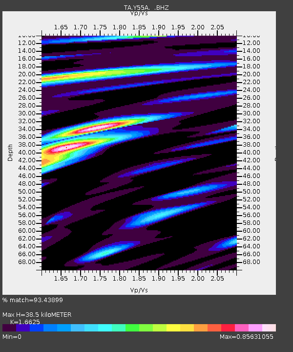
| Estimated Moho Depth: |
38.5 km |
| Estimated Crust Vp/Vs: |
1.66 |
| Assumed Crust Vp: |
6.565 km/s |
| Estimated Crust Vs: |
3.949 km/s |
| Estimated Crust Poisson's Ratio: |
0.22 |
|
| Radial Match: |
93.43899 % |
| Radial Bump: |
338 |
| Transverse Match: |
71.7764 % |
| Transverse Bump: |
400 |
| SOD ConfigId: |
626651 |
| Insert Time: |
2014-06-21 05:49:56.754 +0000 |
| GWidth: |
2.5 |
| Max Bumps: |
400 |
| Tol: |
0.001 |
|
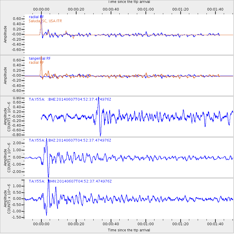
Signal To Noise
| Channel | StoN | STA | LTA |
| TA:Y55A: :BHZ:20140607T04:52:37.474976Z | 17.697693 | 1.3485301E-6 | 7.619808E-8 |
| TA:Y55A: :BHN:20140607T04:52:37.474976Z | 11.157094 | 7.018041E-7 | 6.290205E-8 |
| TA:Y55A: :BHE:20140607T04:52:37.474976Z | 5.423771 | 3.994804E-7 | 7.365363E-8 |
| Arrivals |
| Ps | 4.1 SECOND |
| PpPs | 15 SECOND |
| PsPs/PpSs | 19 SECOND |


