You are here: Home > Network List > 7A - Mid-Atlantic Geophysical Integrative Collaboration Stations List
> Station FOXP Brandywine, West Virginia USA > Earthquake Result Viewer
FOXP Brandywine, West Virginia USA - Earthquake Result Viewer
| Earthquake location: |
Northern Colombia |
| Earthquake latitude/longitude: |
6.8/-73.0 |
| Earthquake time(UTC): |
2015/03/10 (069) 20:55:43 GMT |
| Earthquake Depth: |
147 km |
| Earthquake Magnitude: |
6.2 MWB |
| Earthquake Catalog/Contributor: |
NEIC PDE/NEIC COMCAT |
|
| Network: |
7A Mid-Atlantic Geophysical Integrative Collaboration |
| Station: |
FOXP Brandywine, West Virginia USA |
| Lat/Lon: |
38.63 N/79.25 W |
| Elevation: |
485 m |
|
| Distance: |
32.2 deg |
| Az: |
350.804 deg |
| Baz: |
168.311 deg |
| Ray Param: |
0.07834634 |
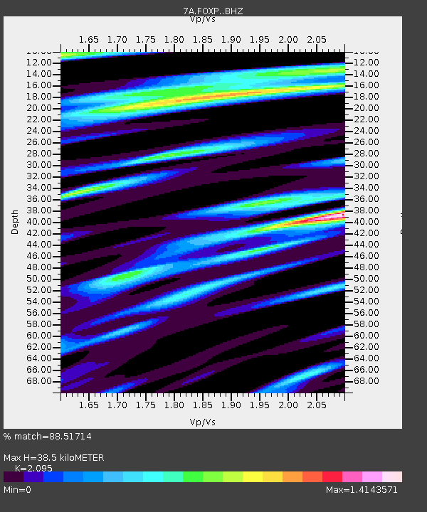
| Estimated Moho Depth: |
38.5 km |
| Estimated Crust Vp/Vs: |
2.10 |
| Assumed Crust Vp: |
6.159 km/s |
| Estimated Crust Vs: |
2.94 km/s |
| Estimated Crust Poisson's Ratio: |
0.35 |
|
| Radial Match: |
88.51714 % |
| Radial Bump: |
400 |
| Transverse Match: |
60.527676 % |
| Transverse Bump: |
400 |
| SOD ConfigId: |
7019011 |
| Insert Time: |
2019-04-17 06:51:18.457 +0000 |
| GWidth: |
2.5 |
| Max Bumps: |
400 |
| Tol: |
0.001 |
|

Signal To Noise
| Channel | StoN | STA | LTA |
| 7A:FOXP: :BHZ:20150310T21:01:26.760011Z | 23.920834 | 1.7372246E-6 | 7.262392E-8 |
| 7A:FOXP: :BHN:20150310T21:01:26.760011Z | 15.218583 | 1.1328874E-6 | 7.4441054E-8 |
| 7A:FOXP: :BHE:20150310T21:01:26.760011Z | 1.3448927 | 2.932211E-7 | 2.1802563E-7 |
| Arrivals |
| Ps | 7.3 SECOND |
| PpPs | 18 SECOND |
| PsPs/PpSs | 25 SECOND |


