You are here: Home > Network List > 7A - Mid-Atlantic Geophysical Integrative Collaboration Stations List
> Station PETO Lost Creek, West Virginia USA > Earthquake Result Viewer
PETO Lost Creek, West Virginia USA - Earthquake Result Viewer
| Earthquake location: |
Northern Colombia |
| Earthquake latitude/longitude: |
6.8/-73.0 |
| Earthquake time(UTC): |
2015/03/10 (069) 20:55:43 GMT |
| Earthquake Depth: |
147 km |
| Earthquake Magnitude: |
6.2 MWB |
| Earthquake Catalog/Contributor: |
NEIC PDE/NEIC COMCAT |
|
| Network: |
7A Mid-Atlantic Geophysical Integrative Collaboration |
| Station: |
PETO Lost Creek, West Virginia USA |
| Lat/Lon: |
39.16 N/80.33 W |
| Elevation: |
0.0 m |
|
| Distance: |
32.9 deg |
| Az: |
349.484 deg |
| Baz: |
166.52 deg |
| Ray Param: |
0.07802506 |
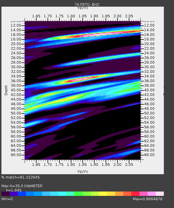
| Estimated Moho Depth: |
35.0 km |
| Estimated Crust Vp/Vs: |
1.85 |
| Assumed Crust Vp: |
6.207 km/s |
| Estimated Crust Vs: |
3.364 km/s |
| Estimated Crust Poisson's Ratio: |
0.29 |
|
| Radial Match: |
91.322845 % |
| Radial Bump: |
400 |
| Transverse Match: |
77.10266 % |
| Transverse Bump: |
400 |
| SOD ConfigId: |
7019011 |
| Insert Time: |
2019-04-17 06:51:28.034 +0000 |
| GWidth: |
2.5 |
| Max Bumps: |
400 |
| Tol: |
0.001 |
|

Signal To Noise
| Channel | StoN | STA | LTA |
| 7A:PETO: :BHZ:20150310T21:01:32.855012Z | 17.277609 | 3.1728055E-6 | 1.8363684E-7 |
| 7A:PETO: :BHN:20150310T21:01:32.855012Z | 18.191021 | 1.4788859E-6 | 8.129758E-8 |
| 7A:PETO: :BHE:20150310T21:01:32.855012Z | 2.4157195 | 2.8462742E-7 | 1.1782304E-7 |
| Arrivals |
| Ps | 5.1 SECOND |
| PpPs | 15 SECOND |
| PsPs/PpSs | 20 SECOND |


