You are here: Home > Network List > 7A - Mid-Atlantic Geophysical Integrative Collaboration Stations List
> Station WIRE Hazelwood, West Virginia USA > Earthquake Result Viewer
WIRE Hazelwood, West Virginia USA - Earthquake Result Viewer
| Earthquake location: |
Northern Colombia |
| Earthquake latitude/longitude: |
6.8/-73.0 |
| Earthquake time(UTC): |
2015/03/10 (069) 20:55:43 GMT |
| Earthquake Depth: |
147 km |
| Earthquake Magnitude: |
6.2 MWB |
| Earthquake Catalog/Contributor: |
NEIC PDE/NEIC COMCAT |
|
| Network: |
7A Mid-Atlantic Geophysical Integrative Collaboration |
| Station: |
WIRE Hazelwood, West Virginia USA |
| Lat/Lon: |
38.85 N/79.84 W |
| Elevation: |
613 m |
|
| Distance: |
32.5 deg |
| Az: |
350.049 deg |
| Baz: |
167.304 deg |
| Ray Param: |
0.07820044 |
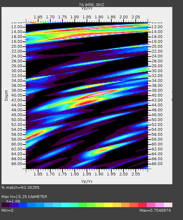
| Estimated Moho Depth: |
15.25 km |
| Estimated Crust Vp/Vs: |
1.86 |
| Assumed Crust Vp: |
6.159 km/s |
| Estimated Crust Vs: |
3.311 km/s |
| Estimated Crust Poisson's Ratio: |
0.30 |
|
| Radial Match: |
93.38295 % |
| Radial Bump: |
341 |
| Transverse Match: |
80.20416 % |
| Transverse Bump: |
400 |
| SOD ConfigId: |
7019011 |
| Insert Time: |
2019-04-17 06:51:29.556 +0000 |
| GWidth: |
2.5 |
| Max Bumps: |
400 |
| Tol: |
0.001 |
|

Signal To Noise
| Channel | StoN | STA | LTA |
| 7A:WIRE: :BHZ:20150310T21:01:29.535005Z | 20.423544 | 1.9190338E-6 | 9.3961845E-8 |
| 7A:WIRE: :BHN:20150310T21:01:29.535005Z | 13.002717 | 1.1108639E-6 | 8.5433214E-8 |
| 7A:WIRE: :BHE:20150310T21:01:29.535005Z | 1.8589163 | 2.2360501E-7 | 1.2028784E-7 |
| Arrivals |
| Ps | 2.3 SECOND |
| PpPs | 6.6 SECOND |
| PsPs/PpSs | 8.9 SECOND |


