You are here: Home > Network List > II - Global Seismograph Network (GSN - IRIS/IDA) Stations List
> Station ABKT Alibek, Turkmenistan > Earthquake Result Viewer
ABKT Alibek, Turkmenistan - Earthquake Result Viewer
| Earthquake location: |
Off East Coast Of Kamchatka |
| Earthquake latitude/longitude: |
52.1/159.5 |
| Earthquake time(UTC): |
1999/03/08 (067) 12:25:48 GMT |
| Earthquake Depth: |
57 km |
| Earthquake Magnitude: |
5.7 MB, 6.9 MW, 6.8 MW |
| Earthquake Catalog/Contributor: |
WHDF/NEIC |
|
| Network: |
II Global Seismograph Network (GSN - IRIS/IDA) |
| Station: |
ABKT Alibek, Turkmenistan |
| Lat/Lon: |
37.93 N/58.12 E |
| Elevation: |
678 m |
|
| Distance: |
67.4 deg |
| Az: |
302.872 deg |
| Baz: |
40.982 deg |
| Ray Param: |
0.05688717 |
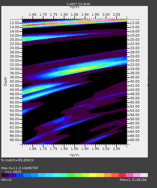
| Estimated Moho Depth: |
11.0 km |
| Estimated Crust Vp/Vs: |
1.89 |
| Assumed Crust Vp: |
6.53 km/s |
| Estimated Crust Vs: |
3.451 km/s |
| Estimated Crust Poisson's Ratio: |
0.31 |
|
| Radial Match: |
95.65924 % |
| Radial Bump: |
400 |
| Transverse Match: |
86.57533 % |
| Transverse Bump: |
400 |
| SOD ConfigId: |
4480 |
| Insert Time: |
2010-03-01 22:57:27.054 +0000 |
| GWidth: |
2.5 |
| Max Bumps: |
400 |
| Tol: |
0.001 |
|
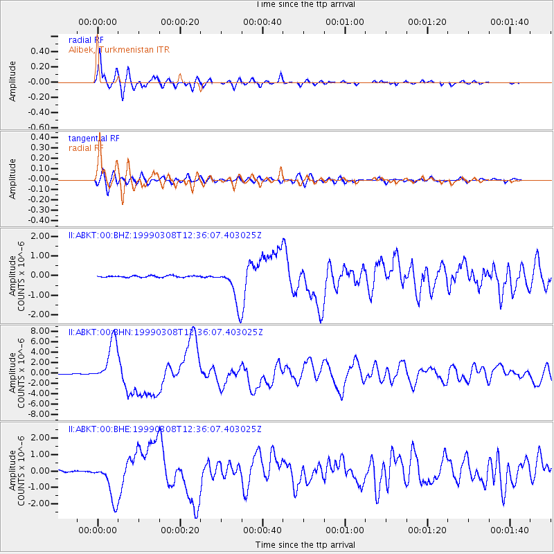
Signal To Noise
| Channel | StoN | STA | LTA |
| II:ABKT:00:BHN:19990308T12:36:07.403025Z | 74.80335 | 4.2588263E-6 | 5.693363E-8 |
| II:ABKT:00:BHE:19990308T12:36:07.403025Z | 24.095469 | 1.2370352E-6 | 5.133892E-8 |
| II:ABKT:00:BHZ:19990308T12:36:07.403025Z | 26.723433 | 1.0119958E-6 | 3.786923E-8 |
| Arrivals |
| Ps | 1.6 SECOND |
| PpPs | 4.7 SECOND |
| PsPs/PpSs | 6.3 SECOND |


