You are here: Home > Network List > TA - USArray Transportable Network (new EarthScope stations) Stations List
> Station N48A Decatur, IN, USA > Earthquake Result Viewer
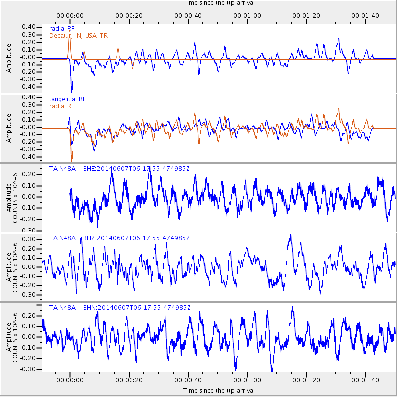
N48A Decatur, IN, USA - Earthquake Result Viewer
*The percent match for this event was below the threshold and hence no stack was calculated.
| Earthquake location: |
Caspian Sea |
| Earthquake latitude/longitude: |
40.3/51.6 |
| Earthquake time(UTC): |
2014/06/07 (158) 06:05:27 GMT |
| Earthquake Depth: |
12 km |
| Earthquake Magnitude: |
5.5 MB |
| Earthquake Catalog/Contributor: |
NEIC PDE/NEIC COMCAT |
|
| Network: |
TA USArray Transportable Network (new EarthScope stations) |
| Station: |
N48A Decatur, IN, USA |
| Lat/Lon: |
40.86 N/85.03 W |
| Elevation: |
250 m |
|
| Distance: |
90.1 deg |
| Az: |
328.598 deg |
| Baz: |
31.678 deg |
| Ray Param: |
$rayparam |
*The percent match for this event was below the threshold and hence was not used in the summary stack. |
|
| Radial Match: |
59.51224 % |
| Radial Bump: |
400 |
| Transverse Match: |
49.418087 % |
| Transverse Bump: |
400 |
| SOD ConfigId: |
626651 |
| Insert Time: |
2014-06-21 06:39:26.039 +0000 |
| GWidth: |
2.5 |
| Max Bumps: |
400 |
| Tol: |
0.001 |
|
Signal To Noise
| Channel | StoN | STA | LTA |
| TA:N48A: :BHZ:20140607T06:17:55.474985Z | 1.7106799 | 1.5741153E-7 | 9.201694E-8 |
| TA:N48A: :BHN:20140607T06:17:55.474985Z | 0.7968703 | 6.769475E-8 | 8.495078E-8 |
| TA:N48A: :BHE:20140607T06:17:55.474985Z | 1.1218985 | 1.05545425E-7 | 9.4077514E-8 |
| Arrivals |
| Ps | |
| PpPs | |
| PsPs/PpSs | |


