You are here: Home > Network List > IU - Global Seismograph Network (GSN - IRIS/USGS) Stations List
> Station PMG Port Moresby, New Guinea > Earthquake Result Viewer
PMG Port Moresby, New Guinea - Earthquake Result Viewer
*The percent match for this event was below the threshold and hence no stack was calculated.
| Earthquake location: |
Kuril Islands |
| Earthquake latitude/longitude: |
50.7/157.1 |
| Earthquake time(UTC): |
2014/06/07 (158) 13:11:37 GMT |
| Earthquake Depth: |
56 km |
| Earthquake Magnitude: |
5.6 M |
| Earthquake Catalog/Contributor: |
NEIC PDE/NEIC ALERT |
|
| Network: |
IU Global Seismograph Network (GSN - IRIS/USGS) |
| Station: |
PMG Port Moresby, New Guinea |
| Lat/Lon: |
9.40 S/147.16 E |
| Elevation: |
90 m |
|
| Distance: |
60.5 deg |
| Az: |
191.301 deg |
| Baz: |
7.254 deg |
| Ray Param: |
$rayparam |
*The percent match for this event was below the threshold and hence was not used in the summary stack. |
|
| Radial Match: |
54.99675 % |
| Radial Bump: |
400 |
| Transverse Match: |
57.113716 % |
| Transverse Bump: |
400 |
| SOD ConfigId: |
626651 |
| Insert Time: |
2014-06-21 13:35:20.943 +0000 |
| GWidth: |
2.5 |
| Max Bumps: |
400 |
| Tol: |
0.001 |
|
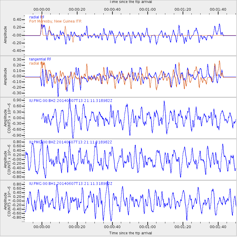
Signal To Noise
| Channel | StoN | STA | LTA |
| IU:PMG:00:BHZ:20140607T13:21:11.318982Z | 1.8825651 | 5.3309293E-7 | 2.831737E-7 |
| IU:PMG:00:BH1:20140607T13:21:11.318982Z | 0.51093566 | 2.2123628E-7 | 4.330022E-7 |
| IU:PMG:00:BH2:20140607T13:21:11.318982Z | 0.47648534 | 1.883613E-7 | 3.9531395E-7 |
| Arrivals |
| Ps | |
| PpPs | |
| PsPs/PpSs | |


