You are here: Home > Network List > LD - Lamont-Doherty Cooperative Seismographic Network Stations List
> Station BRNY Black Rock Forest, Cornwall, NY > Earthquake Result Viewer
BRNY Black Rock Forest, Cornwall, NY - Earthquake Result Viewer
| Earthquake location: |
Northern Colombia |
| Earthquake latitude/longitude: |
6.8/-73.0 |
| Earthquake time(UTC): |
2015/03/10 (069) 20:55:43 GMT |
| Earthquake Depth: |
147 km |
| Earthquake Magnitude: |
6.2 MWB |
| Earthquake Catalog/Contributor: |
NEIC PDE/NEIC COMCAT |
|
| Network: |
LD Lamont-Doherty Cooperative Seismographic Network |
| Station: |
BRNY Black Rock Forest, Cornwall, NY |
| Lat/Lon: |
41.41 N/74.01 W |
| Elevation: |
248 m |
|
| Distance: |
34.5 deg |
| Az: |
358.67 deg |
| Baz: |
178.244 deg |
| Ray Param: |
0.077238046 |
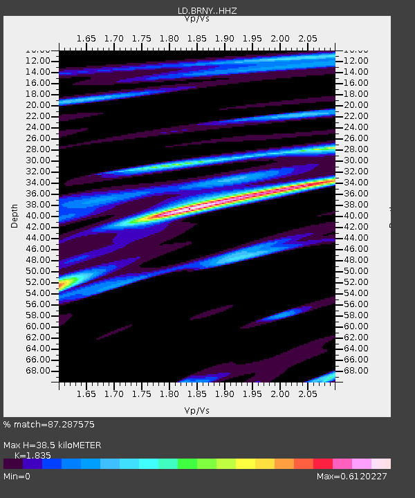
| Estimated Moho Depth: |
38.5 km |
| Estimated Crust Vp/Vs: |
1.84 |
| Assumed Crust Vp: |
6.283 km/s |
| Estimated Crust Vs: |
3.424 km/s |
| Estimated Crust Poisson's Ratio: |
0.29 |
|
| Radial Match: |
87.287575 % |
| Radial Bump: |
255 |
| Transverse Match: |
74.657745 % |
| Transverse Bump: |
400 |
| SOD ConfigId: |
7019011 |
| Insert Time: |
2019-04-17 06:56:46.683 +0000 |
| GWidth: |
2.5 |
| Max Bumps: |
400 |
| Tol: |
0.001 |
|

Signal To Noise
| Channel | StoN | STA | LTA |
| LD:BRNY: :HHZ:20150310T21:01:46.609987Z | 35.66504 | 2.5084469E-6 | 7.03335E-8 |
| LD:BRNY: :HHN:20150310T21:01:46.609987Z | 11.946484 | 1.5324911E-6 | 1.2827968E-7 |
| LD:BRNY: :HHE:20150310T21:01:46.609987Z | 0.9830738 | 1.286839E-7 | 1.3089952E-7 |
| Arrivals |
| Ps | 5.5 SECOND |
| PpPs | 16 SECOND |
| PsPs/PpSs | 22 SECOND |


