You are here: Home > Network List > II - Global Seismograph Network (GSN - IRIS/IDA) Stations List
> Station ABKT Alibek, Turkmenistan > Earthquake Result Viewer
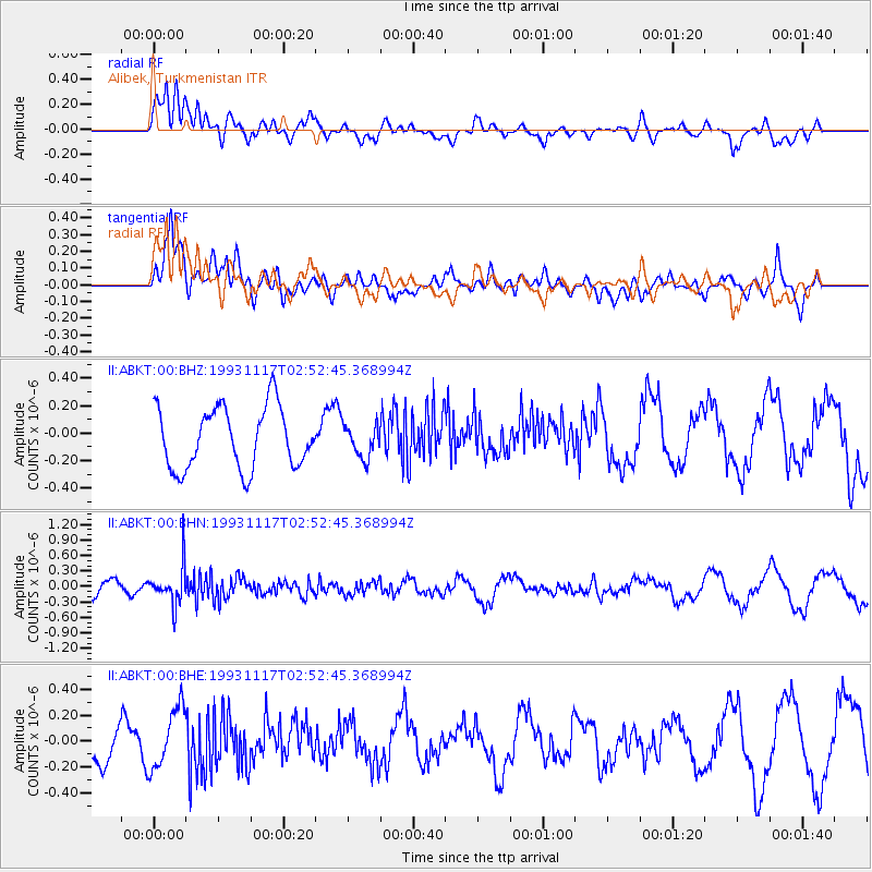
ABKT Alibek, Turkmenistan - Earthquake Result Viewer
*The percent match for this event was below the threshold and hence no stack was calculated.
| Earthquake location: |
Minahassa Peninsula, Sulawesi |
| Earthquake latitude/longitude: |
1.6/124.0 |
| Earthquake time(UTC): |
1993/11/17 (321) 02:42:30 GMT |
| Earthquake Depth: |
246 km |
| Earthquake Magnitude: |
5.5 MB |
| Earthquake Catalog/Contributor: |
WHDF/NEIC |
|
| Network: |
II Global Seismograph Network (GSN - IRIS/IDA) |
| Station: |
ABKT Alibek, Turkmenistan |
| Lat/Lon: |
37.93 N/58.12 E |
| Elevation: |
678 m |
|
| Distance: |
70.2 deg |
| Az: |
309.88 deg |
| Baz: |
104.049 deg |
| Ray Param: |
$rayparam |
*The percent match for this event was below the threshold and hence was not used in the summary stack. |
|
| Radial Match: |
48.175697 % |
| Radial Bump: |
400 |
| Transverse Match: |
66.14372 % |
| Transverse Bump: |
400 |
| SOD ConfigId: |
4480 |
| Insert Time: |
2010-03-01 22:58:29.750 +0000 |
| GWidth: |
2.5 |
| Max Bumps: |
400 |
| Tol: |
0.001 |
|
Signal To Noise
| Channel | StoN | STA | LTA |
| II:ABKT:00:BHN:19931117T02:52:45.368994Z | 2.7229862 | 3.68178E-7 | 1.3521112E-7 |
| II:ABKT:00:BHE:19931117T02:52:45.368994Z | 1.8904253 | 2.3452107E-7 | 1.2405731E-7 |
| II:ABKT:00:BHZ:19931117T02:52:45.368994Z | 0.52406263 | 1.1595183E-7 | 2.2125566E-7 |
| Arrivals |
| Ps | |
| PpPs | |
| PsPs/PpSs | |


