You are here: Home > Network List > N4 - Central and EAstern US Network Stations List
> Station F42A Maple Grove Farm, Niagara, WI, USA > Earthquake Result Viewer
F42A Maple Grove Farm, Niagara, WI, USA - Earthquake Result Viewer
| Earthquake location: |
Northern Colombia |
| Earthquake latitude/longitude: |
6.8/-73.0 |
| Earthquake time(UTC): |
2015/03/10 (069) 20:55:43 GMT |
| Earthquake Depth: |
147 km |
| Earthquake Magnitude: |
6.2 MWB |
| Earthquake Catalog/Contributor: |
NEIC PDE/NEIC COMCAT |
|
| Network: |
N4 Central and EAstern US Network |
| Station: |
F42A Maple Grove Farm, Niagara, WI, USA |
| Lat/Lon: |
45.76 N/88.13 W |
| Elevation: |
358 m |
|
| Distance: |
40.9 deg |
| Az: |
343.814 deg |
| Baz: |
156.71 deg |
| Ray Param: |
0.073547006 |
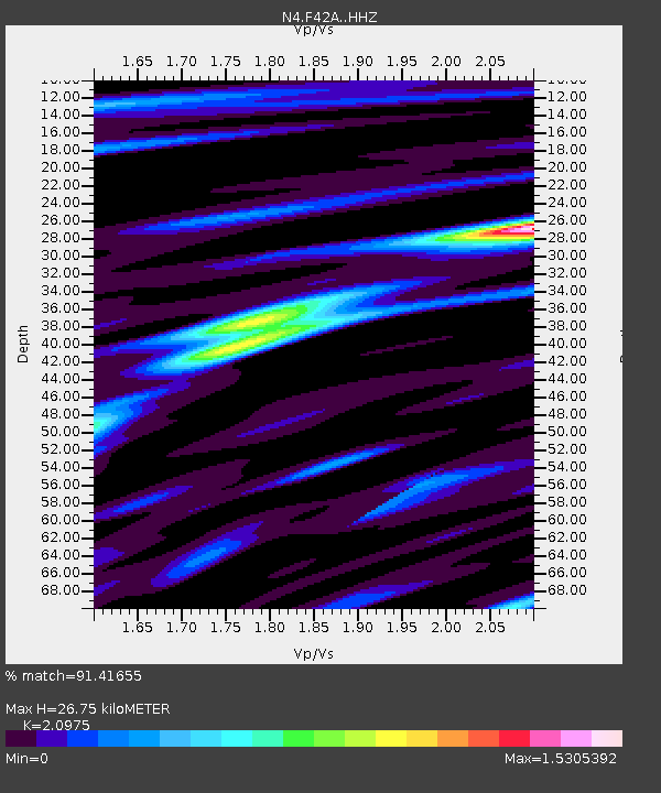
| Estimated Moho Depth: |
26.75 km |
| Estimated Crust Vp/Vs: |
2.10 |
| Assumed Crust Vp: |
6.41 km/s |
| Estimated Crust Vs: |
3.056 km/s |
| Estimated Crust Poisson's Ratio: |
0.35 |
|
| Radial Match: |
91.41655 % |
| Radial Bump: |
304 |
| Transverse Match: |
58.127132 % |
| Transverse Bump: |
400 |
| SOD ConfigId: |
7019011 |
| Insert Time: |
2019-04-17 06:57:26.321 +0000 |
| GWidth: |
2.5 |
| Max Bumps: |
400 |
| Tol: |
0.001 |
|

Signal To Noise
| Channel | StoN | STA | LTA |
| N4:F42A: :HHZ:20150310T21:02:40.820009Z | 25.925499 | 4.837445E-6 | 1.8659023E-7 |
| N4:F42A: :HHN:20150310T21:02:40.820009Z | 35.6193 | 5.739652E-6 | 1.611388E-7 |
| N4:F42A: :HHE:20150310T21:02:40.820009Z | 9.049084 | 2.3623343E-6 | 2.6105783E-7 |
| Arrivals |
| Ps | 4.8 SECOND |
| PpPs | 12 SECOND |
| PsPs/PpSs | 17 SECOND |


