You are here: Home > Network List > N4 - Central and EAstern US Network Stations List
> Station L48A N Adams, MI, USA > Earthquake Result Viewer
L48A N Adams, MI, USA - Earthquake Result Viewer
| Earthquake location: |
Northern Colombia |
| Earthquake latitude/longitude: |
6.8/-73.0 |
| Earthquake time(UTC): |
2015/03/10 (069) 20:55:43 GMT |
| Earthquake Depth: |
147 km |
| Earthquake Magnitude: |
6.2 MWB |
| Earthquake Catalog/Contributor: |
NEIC PDE/NEIC COMCAT |
|
| Network: |
N4 Central and EAstern US Network |
| Station: |
L48A N Adams, MI, USA |
| Lat/Lon: |
41.94 N/84.43 W |
| Elevation: |
369 m |
|
| Distance: |
36.4 deg |
| Az: |
345.589 deg |
| Baz: |
160.654 deg |
| Ray Param: |
0.07618446 |
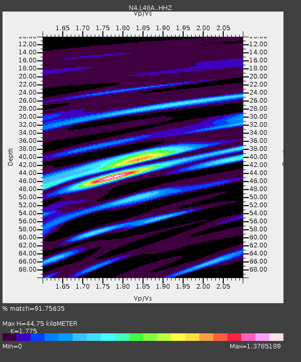
| Estimated Moho Depth: |
44.75 km |
| Estimated Crust Vp/Vs: |
1.77 |
| Assumed Crust Vp: |
6.498 km/s |
| Estimated Crust Vs: |
3.661 km/s |
| Estimated Crust Poisson's Ratio: |
0.27 |
|
| Radial Match: |
91.75635 % |
| Radial Bump: |
308 |
| Transverse Match: |
67.91636 % |
| Transverse Bump: |
400 |
| SOD ConfigId: |
7019011 |
| Insert Time: |
2019-04-17 06:57:40.983 +0000 |
| GWidth: |
2.5 |
| Max Bumps: |
400 |
| Tol: |
0.001 |
|

Signal To Noise
| Channel | StoN | STA | LTA |
| N4:L48A: :HHZ:20150310T21:02:03.230012Z | 40.02315 | 3.3845618E-6 | 8.4565094E-8 |
| N4:L48A: :HHN:20150310T21:02:03.230012Z | 17.715933 | 2.0785849E-6 | 1.1732856E-7 |
| N4:L48A: :HHE:20150310T21:02:03.230012Z | 6.067574 | 6.497011E-7 | 1.0707758E-7 |
| Arrivals |
| Ps | 5.8 SECOND |
| PpPs | 18 SECOND |
| PsPs/PpSs | 23 SECOND |


