You are here: Home > Network List > N4 - Central and EAstern US Network Stations List
> Station U49A Red Boiling Springs, TN, USA > Earthquake Result Viewer
U49A Red Boiling Springs, TN, USA - Earthquake Result Viewer
| Earthquake location: |
Northern Colombia |
| Earthquake latitude/longitude: |
6.8/-73.0 |
| Earthquake time(UTC): |
2015/03/10 (069) 20:55:43 GMT |
| Earthquake Depth: |
147 km |
| Earthquake Magnitude: |
6.2 MWB |
| Earthquake Catalog/Contributor: |
NEIC PDE/NEIC COMCAT |
|
| Network: |
N4 Central and EAstern US Network |
| Station: |
U49A Red Boiling Springs, TN, USA |
| Lat/Lon: |
36.51 N/85.78 W |
| Elevation: |
234 m |
|
| Distance: |
31.8 deg |
| Az: |
340.235 deg |
| Baz: |
155.366 deg |
| Ray Param: |
0.07851721 |
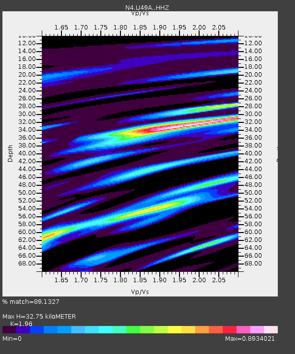
| Estimated Moho Depth: |
32.75 km |
| Estimated Crust Vp/Vs: |
1.96 |
| Assumed Crust Vp: |
6.476 km/s |
| Estimated Crust Vs: |
3.304 km/s |
| Estimated Crust Poisson's Ratio: |
0.32 |
|
| Radial Match: |
89.1327 % |
| Radial Bump: |
228 |
| Transverse Match: |
63.455166 % |
| Transverse Bump: |
400 |
| SOD ConfigId: |
7019011 |
| Insert Time: |
2019-04-17 06:58:16.180 +0000 |
| GWidth: |
2.5 |
| Max Bumps: |
400 |
| Tol: |
0.001 |
|

Signal To Noise
| Channel | StoN | STA | LTA |
| N4:U49A: :HHZ:20150310T21:01:23.329988Z | 34.931957 | 2.5331412E-6 | 7.251644E-8 |
| N4:U49A: :HHN:20150310T21:01:23.329988Z | 15.864413 | 1.4325966E-6 | 9.030253E-8 |
| N4:U49A: :HHE:20150310T21:01:23.329988Z | 8.300873 | 6.627714E-7 | 7.984358E-8 |
| Arrivals |
| Ps | 5.2 SECOND |
| PpPs | 14 SECOND |
| PsPs/PpSs | 19 SECOND |


