You are here: Home > Network List > TA - USArray Transportable Network (new EarthScope stations) Stations List
> Station K49A Clarkson, MI, USA > Earthquake Result Viewer
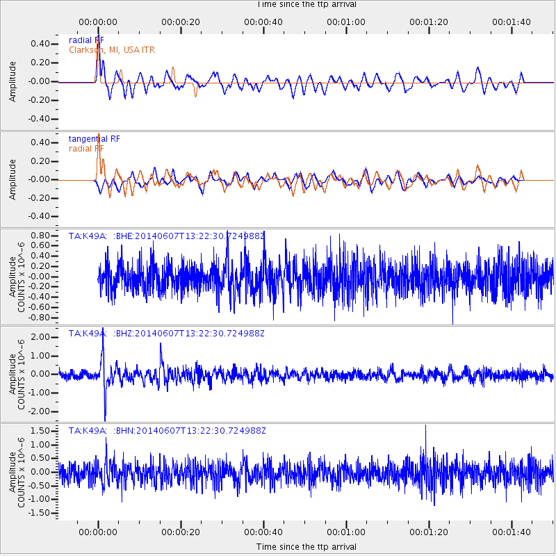
K49A Clarkson, MI, USA - Earthquake Result Viewer
*The percent match for this event was below the threshold and hence no stack was calculated.
| Earthquake location: |
Kuril Islands |
| Earthquake latitude/longitude: |
50.7/157.1 |
| Earthquake time(UTC): |
2014/06/07 (158) 13:11:37 GMT |
| Earthquake Depth: |
56 km |
| Earthquake Magnitude: |
5.6 M |
| Earthquake Catalog/Contributor: |
NEIC PDE/NEIC ALERT |
|
| Network: |
TA USArray Transportable Network (new EarthScope stations) |
| Station: |
K49A Clarkson, MI, USA |
| Lat/Lon: |
42.78 N/83.46 W |
| Elevation: |
336 m |
|
| Distance: |
73.0 deg |
| Az: |
42.103 deg |
| Baz: |
324.617 deg |
| Ray Param: |
$rayparam |
*The percent match for this event was below the threshold and hence was not used in the summary stack. |
|
| Radial Match: |
70.43894 % |
| Radial Bump: |
400 |
| Transverse Match: |
65.430595 % |
| Transverse Bump: |
400 |
| SOD ConfigId: |
626651 |
| Insert Time: |
2014-06-21 14:01:45.909 +0000 |
| GWidth: |
2.5 |
| Max Bumps: |
400 |
| Tol: |
0.001 |
|
Signal To Noise
| Channel | StoN | STA | LTA |
| TA:K49A: :BHZ:20140607T13:22:30.724988Z | 5.22187 | 8.584001E-7 | 1.6438557E-7 |
| TA:K49A: :BHN:20140607T13:22:30.724988Z | 1.5879831 | 4.0632068E-7 | 2.5587218E-7 |
| TA:K49A: :BHE:20140607T13:22:30.724988Z | 1.3762603 | 3.2150768E-7 | 2.3360965E-7 |
| Arrivals |
| Ps | |
| PpPs | |
| PsPs/PpSs | |


