You are here: Home > Network List > TA - USArray Transportable Network (new EarthScope stations) Stations List
> Station MDND Maddock, ND, USA > Earthquake Result Viewer
MDND Maddock, ND, USA - Earthquake Result Viewer
*The percent match for this event was below the threshold and hence no stack was calculated.
| Earthquake location: |
Kuril Islands |
| Earthquake latitude/longitude: |
50.7/157.1 |
| Earthquake time(UTC): |
2014/06/07 (158) 13:11:37 GMT |
| Earthquake Depth: |
56 km |
| Earthquake Magnitude: |
5.6 M |
| Earthquake Catalog/Contributor: |
NEIC PDE/NEIC ALERT |
|
| Network: |
TA USArray Transportable Network (new EarthScope stations) |
| Station: |
MDND Maddock, ND, USA |
| Lat/Lon: |
47.85 N/99.60 W |
| Elevation: |
479 m |
|
| Distance: |
61.8 deg |
| Az: |
48.041 deg |
| Baz: |
315.418 deg |
| Ray Param: |
$rayparam |
*The percent match for this event was below the threshold and hence was not used in the summary stack. |
|
| Radial Match: |
59.193314 % |
| Radial Bump: |
400 |
| Transverse Match: |
59.79364 % |
| Transverse Bump: |
400 |
| SOD ConfigId: |
626651 |
| Insert Time: |
2014-06-21 14:04:27.087 +0000 |
| GWidth: |
2.5 |
| Max Bumps: |
400 |
| Tol: |
0.001 |
|
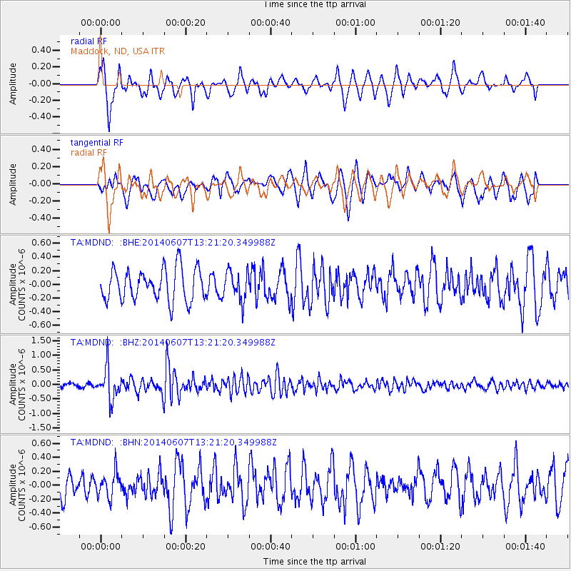
Signal To Noise
| Channel | StoN | STA | LTA |
| TA:MDND: :BHZ:20140607T13:21:20.349988Z | 9.256964 | 5.542876E-7 | 5.9877905E-8 |
| TA:MDND: :BHN:20140607T13:21:20.349988Z | 1.4051399 | 1.8584981E-7 | 1.3226428E-7 |
| TA:MDND: :BHE:20140607T13:21:20.349988Z | 0.9317149 | 2.1748319E-7 | 2.3342247E-7 |
| Arrivals |
| Ps | |
| PpPs | |
| PsPs/PpSs | |


