You are here: Home > Network List > NX - Nanometrics Research Network Stations List
> Station STN20 Seismic station 20 > Earthquake Result Viewer
STN20 Seismic station 20 - Earthquake Result Viewer
| Earthquake location: |
Northern Colombia |
| Earthquake latitude/longitude: |
6.8/-73.0 |
| Earthquake time(UTC): |
2015/03/10 (069) 20:55:43 GMT |
| Earthquake Depth: |
147 km |
| Earthquake Magnitude: |
6.2 MWB |
| Earthquake Catalog/Contributor: |
NEIC PDE/NEIC COMCAT |
|
| Network: |
NX Nanometrics Research Network |
| Station: |
STN20 Seismic station 20 |
| Lat/Lon: |
36.52 N/97.74 W |
| Elevation: |
339 m |
|
| Distance: |
37.2 deg |
| Az: |
326.125 deg |
| Baz: |
136.599 deg |
| Ray Param: |
0.075739235 |
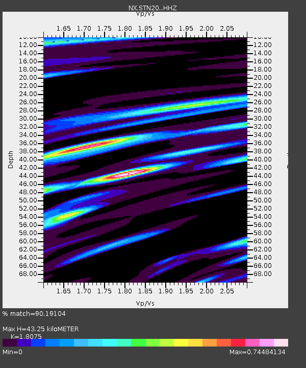
| Estimated Moho Depth: |
43.25 km |
| Estimated Crust Vp/Vs: |
1.81 |
| Assumed Crust Vp: |
6.483 km/s |
| Estimated Crust Vs: |
3.587 km/s |
| Estimated Crust Poisson's Ratio: |
0.28 |
|
| Radial Match: |
90.19104 % |
| Radial Bump: |
400 |
| Transverse Match: |
79.82712 % |
| Transverse Bump: |
400 |
| SOD ConfigId: |
7019011 |
| Insert Time: |
2019-04-17 06:59:19.967 +0000 |
| GWidth: |
2.5 |
| Max Bumps: |
400 |
| Tol: |
0.001 |
|

Signal To Noise
| Channel | StoN | STA | LTA |
| NX:STN20: :HHZ:20150310T21:02:09.79001Z | 51.49667 | 5.2592945E-6 | 1.0212882E-7 |
| NX:STN20: :HH1:20150310T21:02:09.79001Z | 8.235642 | 8.366928E-7 | 1.0159411E-7 |
| NX:STN20: :HH2:20150310T21:02:09.79001Z | 23.353214 | 1.8699451E-6 | 8.007228E-8 |
| Arrivals |
| Ps | 5.8 SECOND |
| PpPs | 17 SECOND |
| PsPs/PpSs | 23 SECOND |


