You are here: Home > Network List > TA - USArray Transportable Network (new EarthScope stations) Stations List
> Station X43A Marvell, AR, USA > Earthquake Result Viewer
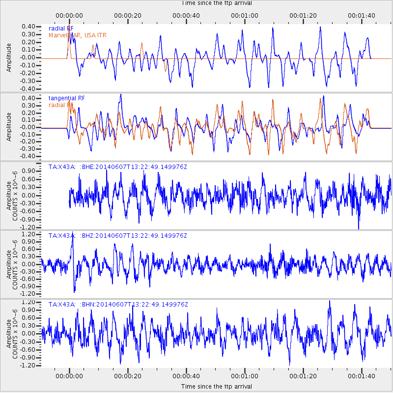
X43A Marvell, AR, USA - Earthquake Result Viewer
*The percent match for this event was below the threshold and hence no stack was calculated.
| Earthquake location: |
Kuril Islands |
| Earthquake latitude/longitude: |
50.7/157.1 |
| Earthquake time(UTC): |
2014/06/07 (158) 13:11:37 GMT |
| Earthquake Depth: |
56 km |
| Earthquake Magnitude: |
5.6 M |
| Earthquake Catalog/Contributor: |
NEIC PDE/NEIC ALERT |
|
| Network: |
TA USArray Transportable Network (new EarthScope stations) |
| Station: |
X43A Marvell, AR, USA |
| Lat/Lon: |
34.52 N/90.88 W |
| Elevation: |
53 m |
|
| Distance: |
76.2 deg |
| Az: |
52.03 deg |
| Baz: |
322.626 deg |
| Ray Param: |
$rayparam |
*The percent match for this event was below the threshold and hence was not used in the summary stack. |
|
| Radial Match: |
56.551483 % |
| Radial Bump: |
400 |
| Transverse Match: |
68.12148 % |
| Transverse Bump: |
400 |
| SOD ConfigId: |
626651 |
| Insert Time: |
2014-06-21 14:10:56.177 +0000 |
| GWidth: |
2.5 |
| Max Bumps: |
400 |
| Tol: |
0.001 |
|
Signal To Noise
| Channel | StoN | STA | LTA |
| TA:X43A: :BHZ:20140607T13:22:49.149976Z | 2.7229753 | 5.114296E-7 | 1.8782016E-7 |
| TA:X43A: :BHN:20140607T13:22:49.149976Z | 1.0108614 | 3.9404702E-7 | 3.8981312E-7 |
| TA:X43A: :BHE:20140607T13:22:49.149976Z | 1.1260278 | 3.881685E-7 | 3.4472373E-7 |
| Arrivals |
| Ps | |
| PpPs | |
| PsPs/PpSs | |


