You are here: Home > Network List > US - United States National Seismic Network Stations List
> Station AMTX Amarillo, Texas, USA > Earthquake Result Viewer
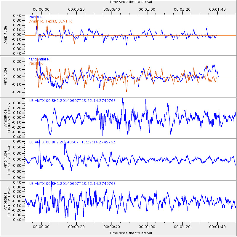
AMTX Amarillo, Texas, USA - Earthquake Result Viewer
*The percent match for this event was below the threshold and hence no stack was calculated.
| Earthquake location: |
Kuril Islands |
| Earthquake latitude/longitude: |
50.7/157.1 |
| Earthquake time(UTC): |
2014/06/07 (158) 13:11:37 GMT |
| Earthquake Depth: |
56 km |
| Earthquake Magnitude: |
5.6 M |
| Earthquake Catalog/Contributor: |
NEIC PDE/NEIC ALERT |
|
| Network: |
US United States National Seismic Network |
| Station: |
AMTX Amarillo, Texas, USA |
| Lat/Lon: |
34.53 N/101.41 W |
| Elevation: |
1010 m |
|
| Distance: |
70.7 deg |
| Az: |
59.03 deg |
| Baz: |
318.676 deg |
| Ray Param: |
$rayparam |
*The percent match for this event was below the threshold and hence was not used in the summary stack. |
|
| Radial Match: |
57.142036 % |
| Radial Bump: |
400 |
| Transverse Match: |
36.787617 % |
| Transverse Bump: |
400 |
| SOD ConfigId: |
626651 |
| Insert Time: |
2014-06-21 14:12:04.211 +0000 |
| GWidth: |
2.5 |
| Max Bumps: |
400 |
| Tol: |
0.001 |
|
Signal To Noise
| Channel | StoN | STA | LTA |
| US:AMTX:00:BHZ:20140607T13:22:14.274976Z | 2.617826 | 2.8392216E-7 | 1.0845723E-7 |
| US:AMTX:00:BH1:20140607T13:22:14.274976Z | 1.5264713 | 1.4190917E-7 | 9.29655E-8 |
| US:AMTX:00:BH2:20140607T13:22:14.274976Z | 1.394738 | 1.5112218E-7 | 1.08351664E-7 |
| Arrivals |
| Ps | |
| PpPs | |
| PsPs/PpSs | |


