You are here: Home > Network List > US - United States National Seismic Network Stations List
> Station MNTX Cornudas Mountains, Texas, USA > Earthquake Result Viewer
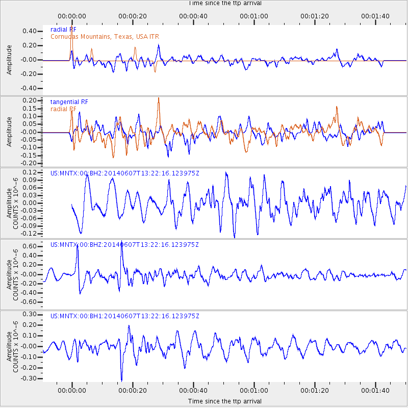
MNTX Cornudas Mountains, Texas, USA - Earthquake Result Viewer
*The percent match for this event was below the threshold and hence no stack was calculated.
| Earthquake location: |
Kuril Islands |
| Earthquake latitude/longitude: |
50.7/157.1 |
| Earthquake time(UTC): |
2014/06/07 (158) 13:11:37 GMT |
| Earthquake Depth: |
56 km |
| Earthquake Magnitude: |
5.6 M |
| Earthquake Catalog/Contributor: |
NEIC PDE/NEIC ALERT |
|
| Network: |
US United States National Seismic Network |
| Station: |
MNTX Cornudas Mountains, Texas, USA |
| Lat/Lon: |
31.70 N/105.38 W |
| Elevation: |
404 m |
|
| Distance: |
70.6 deg |
| Az: |
63.66 deg |
| Baz: |
318.052 deg |
| Ray Param: |
$rayparam |
*The percent match for this event was below the threshold and hence was not used in the summary stack. |
|
| Radial Match: |
48.921436 % |
| Radial Bump: |
400 |
| Transverse Match: |
68.05472 % |
| Transverse Bump: |
400 |
| SOD ConfigId: |
626651 |
| Insert Time: |
2014-06-21 14:14:16.987 +0000 |
| GWidth: |
2.5 |
| Max Bumps: |
400 |
| Tol: |
0.001 |
|
Signal To Noise
| Channel | StoN | STA | LTA |
| US:MNTX:00:BHZ:20140607T13:22:16.123975Z | 3.2213824 | 2.5309504E-7 | 7.856721E-8 |
| US:MNTX:00:BH1:20140607T13:22:16.123975Z | 1.422506 | 6.580423E-8 | 4.6259366E-8 |
| US:MNTX:00:BH2:20140607T13:22:16.123975Z | 0.91657984 | 4.926972E-8 | 5.3753876E-8 |
| Arrivals |
| Ps | |
| PpPs | |
| PsPs/PpSs | |


