You are here: Home > Network List > UW - Pacific Northwest Regional Seismic Network Stations List
> Station MRBL Marblemount, WA, USA > Earthquake Result Viewer
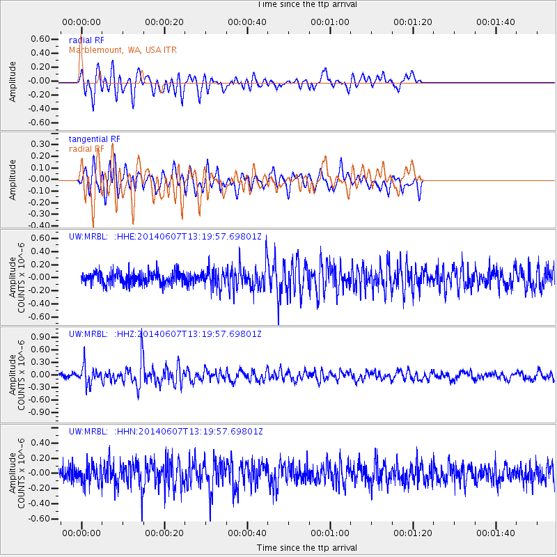
MRBL Marblemount, WA, USA - Earthquake Result Viewer
*The percent match for this event was below the threshold and hence no stack was calculated.
| Earthquake location: |
Kuril Islands |
| Earthquake latitude/longitude: |
50.7/157.1 |
| Earthquake time(UTC): |
2014/06/07 (158) 13:11:37 GMT |
| Earthquake Depth: |
56 km |
| Earthquake Magnitude: |
5.6 M |
| Earthquake Catalog/Contributor: |
NEIC PDE/NEIC ALERT |
|
| Network: |
UW Pacific Northwest Regional Seismic Network |
| Station: |
MRBL Marblemount, WA, USA |
| Lat/Lon: |
48.52 N/121.48 W |
| Elevation: |
75 m |
|
| Distance: |
50.2 deg |
| Az: |
58.796 deg |
| Baz: |
305.123 deg |
| Ray Param: |
$rayparam |
*The percent match for this event was below the threshold and hence was not used in the summary stack. |
|
| Radial Match: |
65.09926 % |
| Radial Bump: |
400 |
| Transverse Match: |
65.99499 % |
| Transverse Bump: |
400 |
| SOD ConfigId: |
626651 |
| Insert Time: |
2014-06-21 14:17:39.979 +0000 |
| GWidth: |
2.5 |
| Max Bumps: |
400 |
| Tol: |
0.001 |
|
Signal To Noise
| Channel | StoN | STA | LTA |
| UW:MRBL: :HHZ:20140607T13:19:57.69801Z | 3.8000743 | 2.1135943E-7 | 5.5619818E-8 |
| UW:MRBL: :HHN:20140607T13:19:57.69801Z | 1.2399111 | 1.15234904E-7 | 9.293804E-8 |
| UW:MRBL: :HHE:20140607T13:19:57.69801Z | 1.4736521 | 1.3075955E-7 | 8.8731625E-8 |
| Arrivals |
| Ps | |
| PpPs | |
| PsPs/PpSs | |


