You are here: Home > Network List > TA - USArray Transportable Network (new EarthScope stations) Stations List
> Station G57A Newington, ON, CAN > Earthquake Result Viewer
G57A Newington, ON, CAN - Earthquake Result Viewer
| Earthquake location: |
Northern Colombia |
| Earthquake latitude/longitude: |
6.8/-73.0 |
| Earthquake time(UTC): |
2015/03/10 (069) 20:55:43 GMT |
| Earthquake Depth: |
147 km |
| Earthquake Magnitude: |
6.2 MWB |
| Earthquake Catalog/Contributor: |
NEIC PDE/NEIC COMCAT |
|
| Network: |
TA USArray Transportable Network (new EarthScope stations) |
| Station: |
G57A Newington, ON, CAN |
| Lat/Lon: |
45.10 N/74.99 W |
| Elevation: |
96 m |
|
| Distance: |
38.2 deg |
| Az: |
357.738 deg |
| Baz: |
176.827 deg |
| Ray Param: |
0.075187474 |
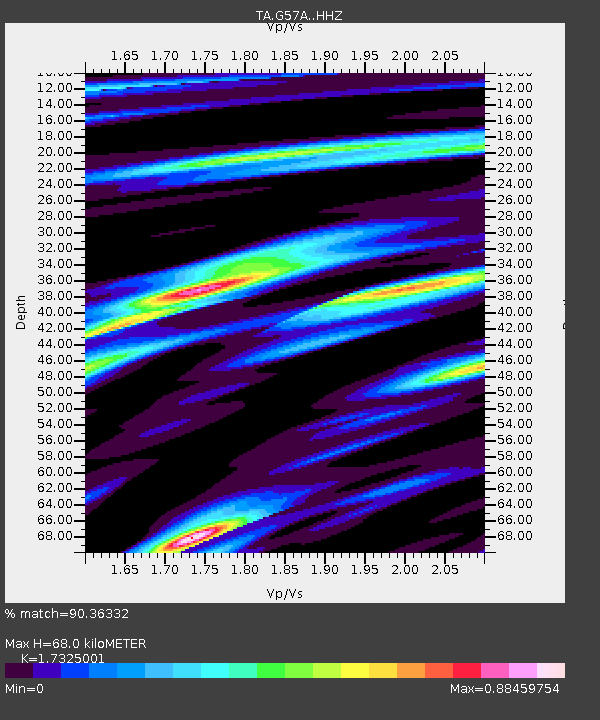
| Estimated Moho Depth: |
68.0 km |
| Estimated Crust Vp/Vs: |
1.73 |
| Assumed Crust Vp: |
6.419 km/s |
| Estimated Crust Vs: |
3.705 km/s |
| Estimated Crust Poisson's Ratio: |
0.25 |
|
| Radial Match: |
90.36332 % |
| Radial Bump: |
247 |
| Transverse Match: |
62.71597 % |
| Transverse Bump: |
400 |
| SOD ConfigId: |
7019011 |
| Insert Time: |
2019-04-17 07:01:09.136 +0000 |
| GWidth: |
2.5 |
| Max Bumps: |
400 |
| Tol: |
0.001 |
|
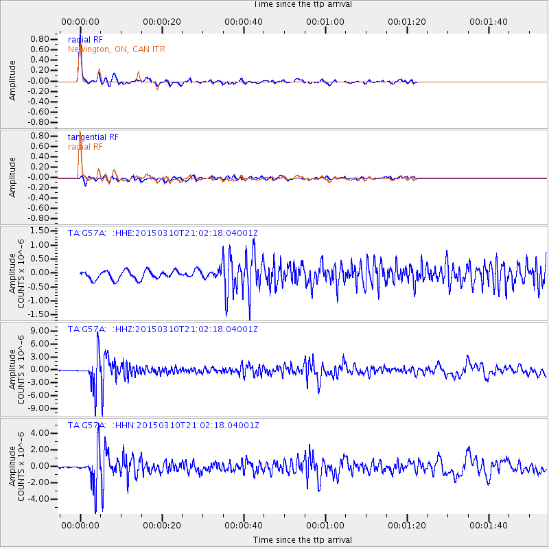
Signal To Noise
| Channel | StoN | STA | LTA |
| TA:G57A: :HHZ:20150310T21:02:18.04001Z | 42.027687 | 3.6116387E-6 | 8.5934744E-8 |
| TA:G57A: :HHN:20150310T21:02:18.04001Z | 17.901741 | 2.1796793E-6 | 1.2175795E-7 |
| TA:G57A: :HHE:20150310T21:02:18.04001Z | 1.066365 | 1.5874224E-7 | 1.4886294E-7 |
| Arrivals |
| Ps | 8.3 SECOND |
| PpPs | 27 SECOND |
| PsPs/PpSs | 35 SECOND |


