You are here: Home > Network List > TA - USArray Transportable Network (new EarthScope stations) Stations List
> Station G60A Masonville, QC, CAN > Earthquake Result Viewer
G60A Masonville, QC, CAN - Earthquake Result Viewer
| Earthquake location: |
Northern Colombia |
| Earthquake latitude/longitude: |
6.8/-73.0 |
| Earthquake time(UTC): |
2015/03/10 (069) 20:55:43 GMT |
| Earthquake Depth: |
147 km |
| Earthquake Magnitude: |
6.2 MWB |
| Earthquake Catalog/Contributor: |
NEIC PDE/NEIC COMCAT |
|
| Network: |
TA USArray Transportable Network (new EarthScope stations) |
| Station: |
G60A Masonville, QC, CAN |
| Lat/Lon: |
45.10 N/72.33 W |
| Elevation: |
391 m |
|
| Distance: |
38.1 deg |
| Az: |
0.777 deg |
| Baz: |
181.09 deg |
| Ray Param: |
0.075210355 |
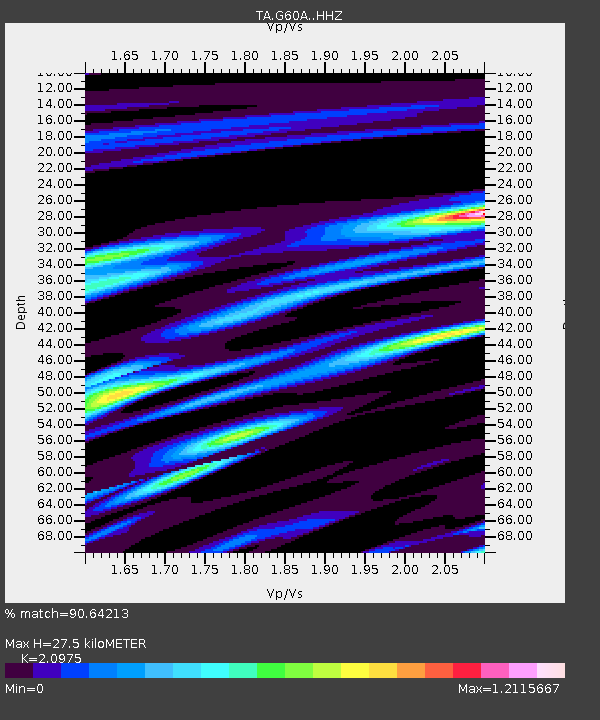
| Estimated Moho Depth: |
27.5 km |
| Estimated Crust Vp/Vs: |
2.10 |
| Assumed Crust Vp: |
6.419 km/s |
| Estimated Crust Vs: |
3.06 km/s |
| Estimated Crust Poisson's Ratio: |
0.35 |
|
| Radial Match: |
90.64213 % |
| Radial Bump: |
309 |
| Transverse Match: |
79.02333 % |
| Transverse Bump: |
400 |
| SOD ConfigId: |
7019011 |
| Insert Time: |
2019-04-17 07:01:10.827 +0000 |
| GWidth: |
2.5 |
| Max Bumps: |
400 |
| Tol: |
0.001 |
|
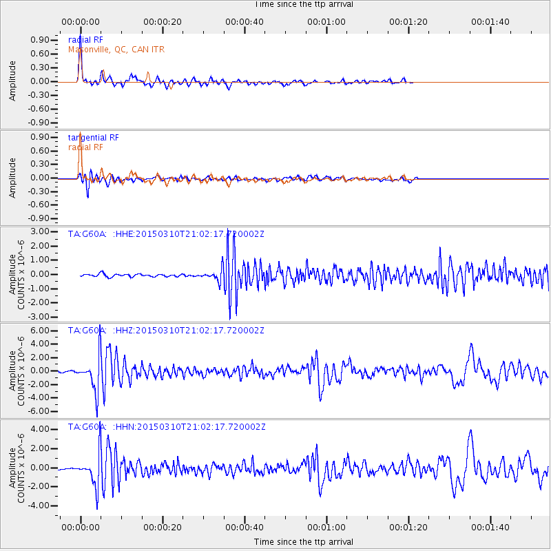
Signal To Noise
| Channel | StoN | STA | LTA |
| TA:G60A: :HHZ:20150310T21:02:17.720002Z | 24.901196 | 2.5373263E-6 | 1.01895765E-7 |
| TA:G60A: :HHN:20150310T21:02:17.720002Z | 12.843462 | 1.6637302E-6 | 1.2953907E-7 |
| TA:G60A: :HHE:20150310T21:02:17.720002Z | 4.2284093 | 4.0629806E-7 | 9.608769E-8 |
| Arrivals |
| Ps | 5.0 SECOND |
| PpPs | 12 SECOND |
| PsPs/PpSs | 17 SECOND |


