You are here: Home > Network List > TA - USArray Transportable Network (new EarthScope stations) Stations List
> Station H57A Richville, NY, USA > Earthquake Result Viewer
H57A Richville, NY, USA - Earthquake Result Viewer
| Earthquake location: |
Northern Colombia |
| Earthquake latitude/longitude: |
6.8/-73.0 |
| Earthquake time(UTC): |
2015/03/10 (069) 20:55:43 GMT |
| Earthquake Depth: |
147 km |
| Earthquake Magnitude: |
6.2 MWB |
| Earthquake Catalog/Contributor: |
NEIC PDE/NEIC COMCAT |
|
| Network: |
TA USArray Transportable Network (new EarthScope stations) |
| Station: |
H57A Richville, NY, USA |
| Lat/Lon: |
44.46 N/75.39 W |
| Elevation: |
132 m |
|
| Distance: |
37.5 deg |
| Az: |
357.204 deg |
| Baz: |
176.121 deg |
| Ray Param: |
0.075542934 |
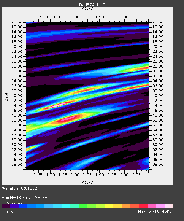
| Estimated Moho Depth: |
43.75 km |
| Estimated Crust Vp/Vs: |
1.73 |
| Assumed Crust Vp: |
6.419 km/s |
| Estimated Crust Vs: |
3.721 km/s |
| Estimated Crust Poisson's Ratio: |
0.25 |
|
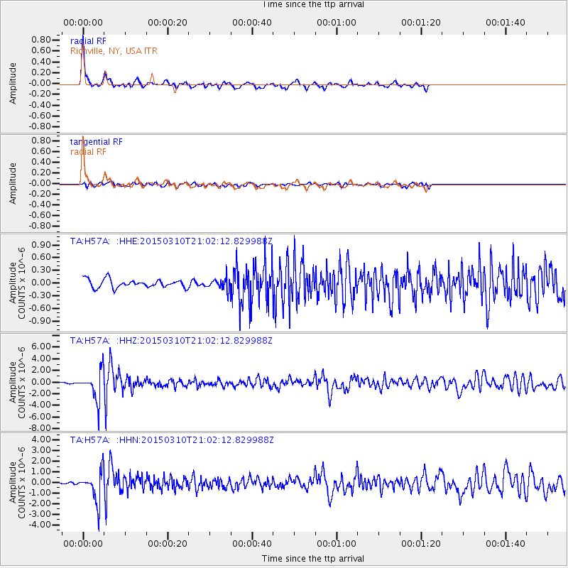
| Radial Match: |
86.1852 % |
| Radial Bump: |
277 |
| Transverse Match: |
57.379814 % |
| Transverse Bump: |
400 |
| SOD ConfigId: |
7019011 |
| Insert Time: |
2019-04-17 07:01:18.137 +0000 |
| GWidth: |
2.5 |
| Max Bumps: |
400 |
| Tol: |
0.001 |
|
Signal To Noise
| Channel | StoN | STA | LTA |
| TA:H57A: :HHZ:20150310T21:02:12.829988Z | 25.64215 | 2.5349539E-6 | 9.885886E-8 |
| TA:H57A: :HHN:20150310T21:02:12.829988Z | 12.031398 | 1.4808289E-6 | 1.2308037E-7 |
| TA:H57A: :HHE:20150310T21:02:12.829988Z | 1.3176532 | 1.2842003E-7 | 9.746117E-8 |
| Arrivals |
| Ps | 5.3 SECOND |
| PpPs | 17 SECOND |
| PsPs/PpSs | 23 SECOND |


