You are here: Home > Network List > TA - USArray Transportable Network (new EarthScope stations) Stations List
> Station H64A Troy, ME, USA > Earthquake Result Viewer
H64A Troy, ME, USA - Earthquake Result Viewer
| Earthquake location: |
Northern Colombia |
| Earthquake latitude/longitude: |
6.8/-73.0 |
| Earthquake time(UTC): |
2015/03/10 (069) 20:55:43 GMT |
| Earthquake Depth: |
147 km |
| Earthquake Magnitude: |
6.2 MWB |
| Earthquake Catalog/Contributor: |
NEIC PDE/NEIC COMCAT |
|
| Network: |
TA USArray Transportable Network (new EarthScope stations) |
| Station: |
H64A Troy, ME, USA |
| Lat/Lon: |
44.64 N/69.22 W |
| Elevation: |
158 m |
|
| Distance: |
37.8 deg |
| Az: |
4.416 deg |
| Baz: |
186.148 deg |
| Ray Param: |
0.075390786 |
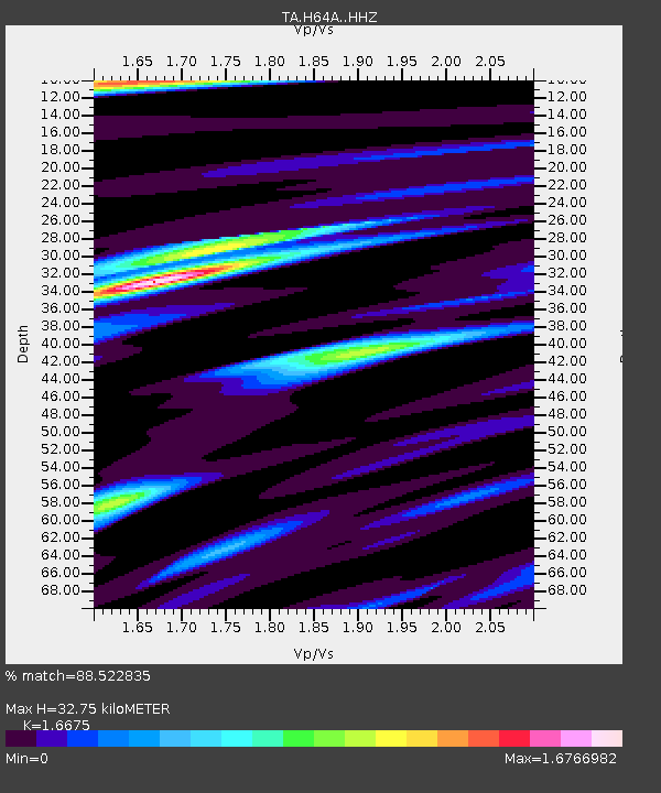
| Estimated Moho Depth: |
32.75 km |
| Estimated Crust Vp/Vs: |
1.67 |
| Assumed Crust Vp: |
6.419 km/s |
| Estimated Crust Vs: |
3.85 km/s |
| Estimated Crust Poisson's Ratio: |
0.22 |
|
| Radial Match: |
88.522835 % |
| Radial Bump: |
356 |
| Transverse Match: |
63.06257 % |
| Transverse Bump: |
400 |
| SOD ConfigId: |
7019011 |
| Insert Time: |
2019-04-17 07:01:23.498 +0000 |
| GWidth: |
2.5 |
| Max Bumps: |
400 |
| Tol: |
0.001 |
|

Signal To Noise
| Channel | StoN | STA | LTA |
| TA:H64A: :HHZ:20150310T21:02:15.089998Z | 16.893898 | 2.3181274E-6 | 1.3721686E-7 |
| TA:H64A: :HHN:20150310T21:02:15.089998Z | 12.048734 | 1.3740657E-6 | 1.14042344E-7 |
| TA:H64A: :HHE:20150310T21:02:15.089998Z | 2.7019894 | 2.9720823E-7 | 1.0999608E-7 |
| Arrivals |
| Ps | 3.7 SECOND |
| PpPs | 13 SECOND |
| PsPs/PpSs | 16 SECOND |


