You are here: Home > Network List > TA - USArray Transportable Network (new EarthScope stations) Stations List
> Station I57A Carthage, NY, USA > Earthquake Result Viewer
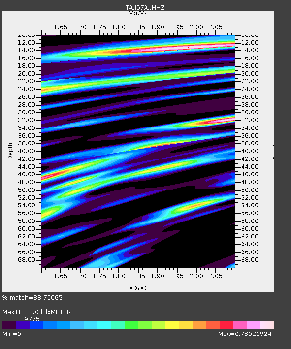
I57A Carthage, NY, USA - Earthquake Result Viewer
| Earthquake location: |
Northern Colombia |
| Earthquake latitude/longitude: |
6.8/-73.0 |
| Earthquake time(UTC): |
2015/03/10 (069) 20:55:43 GMT |
| Earthquake Depth: |
147 km |
| Earthquake Magnitude: |
6.2 MWB |
| Earthquake Catalog/Contributor: |
NEIC PDE/NEIC COMCAT |
|
| Network: |
TA USArray Transportable Network (new EarthScope stations) |
| Station: |
I57A Carthage, NY, USA |
| Lat/Lon: |
43.94 N/75.66 W |
| Elevation: |
321 m |
|
| Distance: |
37.0 deg |
| Az: |
356.823 deg |
| Baz: |
175.631 deg |
| Ray Param: |
0.0758342 |
| Estimated Moho Depth: |
13.0 km |
| Estimated Crust Vp/Vs: |
1.98 |
| Assumed Crust Vp: |
6.419 km/s |
| Estimated Crust Vs: |
3.246 km/s |
| Estimated Crust Poisson's Ratio: |
0.33 |
|
| Radial Match: |
88.70065 % |
| Radial Bump: |
368 |
| Transverse Match: |
64.07845 % |
| Transverse Bump: |
400 |
| SOD ConfigId: |
7019011 |
| Insert Time: |
2019-04-17 07:01:31.174 +0000 |
| GWidth: |
2.5 |
| Max Bumps: |
400 |
| Tol: |
0.001 |
|

Signal To Noise
| Channel | StoN | STA | LTA |
| TA:I57A: :HHZ:20150310T21:02:08.549989Z | 18.856436 | 2.338868E-6 | 1.2403552E-7 |
| TA:I57A: :HHN:20150310T21:02:08.549989Z | 20.22832 | 1.3611273E-6 | 6.72882E-8 |
| TA:I57A: :HHE:20150310T21:02:08.549989Z | 1.1805747 | 1.2658245E-7 | 1.07221034E-7 |
| Arrivals |
| Ps | 2.1 SECOND |
| PpPs | 5.7 SECOND |
| PsPs/PpSs | 7.8 SECOND |


