You are here: Home > Network List > TA - USArray Transportable Network (new EarthScope stations) Stations List
> Station I58A Old Forge, NY, USA > Earthquake Result Viewer
I58A Old Forge, NY, USA - Earthquake Result Viewer
| Earthquake location: |
Northern Colombia |
| Earthquake latitude/longitude: |
6.8/-73.0 |
| Earthquake time(UTC): |
2015/03/10 (069) 20:55:43 GMT |
| Earthquake Depth: |
147 km |
| Earthquake Magnitude: |
6.2 MWB |
| Earthquake Catalog/Contributor: |
NEIC PDE/NEIC COMCAT |
|
| Network: |
TA USArray Transportable Network (new EarthScope stations) |
| Station: |
I58A Old Forge, NY, USA |
| Lat/Lon: |
43.69 N/74.97 W |
| Elevation: |
599 m |
|
| Distance: |
36.8 deg |
| Az: |
357.622 deg |
| Baz: |
176.743 deg |
| Ray Param: |
0.07599514 |
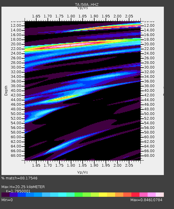
| Estimated Moho Depth: |
20.25 km |
| Estimated Crust Vp/Vs: |
1.80 |
| Assumed Crust Vp: |
6.419 km/s |
| Estimated Crust Vs: |
3.576 km/s |
| Estimated Crust Poisson's Ratio: |
0.27 |
|
| Radial Match: |
88.17546 % |
| Radial Bump: |
374 |
| Transverse Match: |
62.65111 % |
| Transverse Bump: |
400 |
| SOD ConfigId: |
7019011 |
| Insert Time: |
2019-04-17 07:01:32.201 +0000 |
| GWidth: |
2.5 |
| Max Bumps: |
400 |
| Tol: |
0.001 |
|
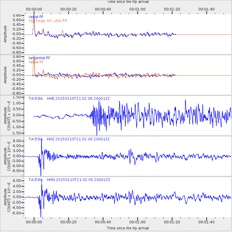
Signal To Noise
| Channel | StoN | STA | LTA |
| TA:I58A: :HHZ:20150310T21:02:06.200013Z | 32.275795 | 3.4695602E-6 | 1.07497286E-7 |
| TA:I58A: :HHN:20150310T21:02:06.200013Z | 13.03814 | 2.1418198E-6 | 1.6427343E-7 |
| TA:I58A: :HHE:20150310T21:02:06.200013Z | 2.5856588 | 2.4336438E-7 | 9.412084E-8 |
| Arrivals |
| Ps | 2.7 SECOND |
| PpPs | 8.2 SECOND |
| PsPs/PpSs | 11 SECOND |


