You are here: Home > Network List > TA - USArray Transportable Network (new EarthScope stations) Stations List
> Station J57A Williamstown, NY, USA > Earthquake Result Viewer
J57A Williamstown, NY, USA - Earthquake Result Viewer
| Earthquake location: |
Northern Colombia |
| Earthquake latitude/longitude: |
6.8/-73.0 |
| Earthquake time(UTC): |
2015/03/10 (069) 20:55:43 GMT |
| Earthquake Depth: |
147 km |
| Earthquake Magnitude: |
6.2 MWB |
| Earthquake Catalog/Contributor: |
NEIC PDE/NEIC COMCAT |
|
| Network: |
TA USArray Transportable Network (new EarthScope stations) |
| Station: |
J57A Williamstown, NY, USA |
| Lat/Lon: |
43.41 N/76.00 W |
| Elevation: |
191 m |
|
| Distance: |
36.5 deg |
| Az: |
356.344 deg |
| Baz: |
175.016 deg |
| Ray Param: |
0.076120235 |
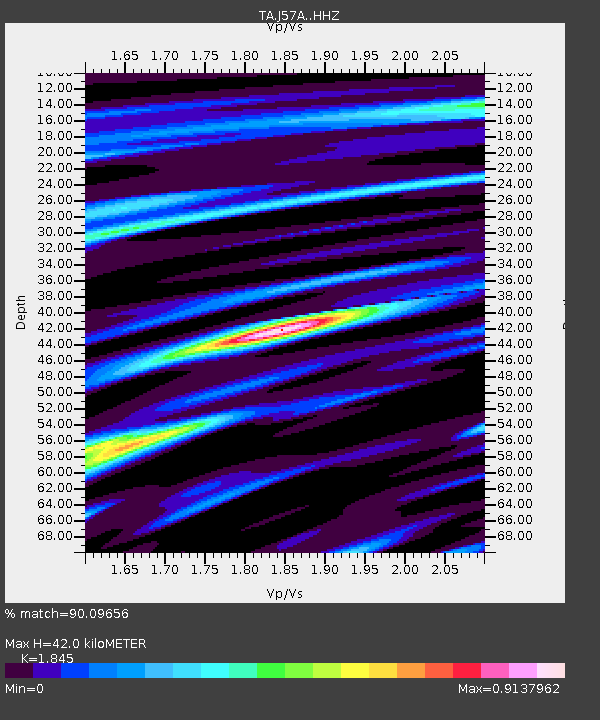
| Estimated Moho Depth: |
42.0 km |
| Estimated Crust Vp/Vs: |
1.85 |
| Assumed Crust Vp: |
6.419 km/s |
| Estimated Crust Vs: |
3.479 km/s |
| Estimated Crust Poisson's Ratio: |
0.29 |
|
| Radial Match: |
90.09656 % |
| Radial Bump: |
265 |
| Transverse Match: |
69.76103 % |
| Transverse Bump: |
379 |
| SOD ConfigId: |
7019011 |
| Insert Time: |
2019-04-17 07:01:38.918 +0000 |
| GWidth: |
2.5 |
| Max Bumps: |
400 |
| Tol: |
0.001 |
|
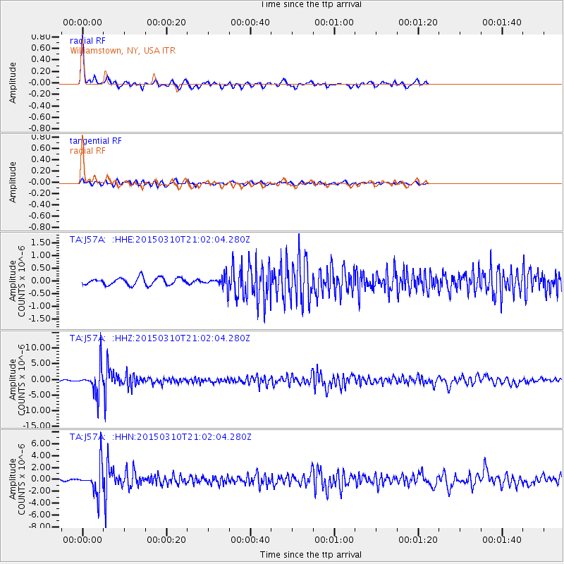
Signal To Noise
| Channel | StoN | STA | LTA |
| TA:J57A: :HHZ:20150310T21:02:04.280Z | 42.549667 | 4.230747E-6 | 9.9430785E-8 |
| TA:J57A: :HHN:20150310T21:02:04.280Z | 31.20332 | 2.5163472E-6 | 8.0643574E-8 |
| TA:J57A: :HHE:20150310T21:02:04.280Z | 1.7256106 | 2.411053E-7 | 1.3972175E-7 |
| Arrivals |
| Ps | 5.9 SECOND |
| PpPs | 17 SECOND |
| PsPs/PpSs | 23 SECOND |


