You are here: Home > Network List > TA - USArray Transportable Network (new EarthScope stations) Stations List
> Station J59A Piesco, NY, USA > Earthquake Result Viewer
J59A Piesco, NY, USA - Earthquake Result Viewer
| Earthquake location: |
Northern Colombia |
| Earthquake latitude/longitude: |
6.8/-73.0 |
| Earthquake time(UTC): |
2015/03/10 (069) 20:55:43 GMT |
| Earthquake Depth: |
147 km |
| Earthquake Magnitude: |
6.2 MWB |
| Earthquake Catalog/Contributor: |
NEIC PDE/NEIC COMCAT |
|
| Network: |
TA USArray Transportable Network (new EarthScope stations) |
| Station: |
J59A Piesco, NY, USA |
| Lat/Lon: |
43.46 N/74.50 W |
| Elevation: |
541 m |
|
| Distance: |
36.5 deg |
| Az: |
358.173 deg |
| Baz: |
177.508 deg |
| Ray Param: |
0.07612898 |
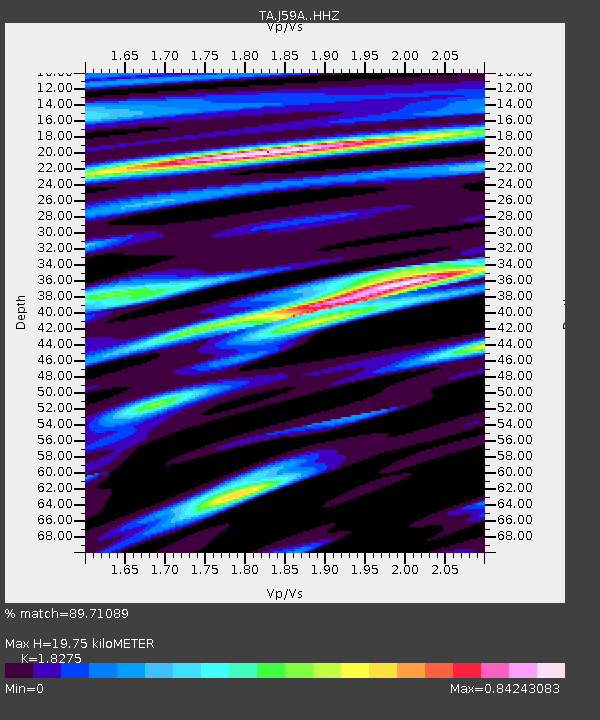
| Estimated Moho Depth: |
19.75 km |
| Estimated Crust Vp/Vs: |
1.83 |
| Assumed Crust Vp: |
6.419 km/s |
| Estimated Crust Vs: |
3.513 km/s |
| Estimated Crust Poisson's Ratio: |
0.29 |
|
| Radial Match: |
89.71089 % |
| Radial Bump: |
230 |
| Transverse Match: |
75.729454 % |
| Transverse Bump: |
338 |
| SOD ConfigId: |
7019011 |
| Insert Time: |
2019-04-17 07:01:40.146 +0000 |
| GWidth: |
2.5 |
| Max Bumps: |
400 |
| Tol: |
0.001 |
|

Signal To Noise
| Channel | StoN | STA | LTA |
| TA:J59A: :HHZ:20150310T21:02:04.149995Z | 15.940264 | 2.3170808E-6 | 1.4536026E-7 |
| TA:J59A: :HHN:20150310T21:02:04.149995Z | 21.374243 | 1.365956E-6 | 6.390664E-8 |
| TA:J59A: :HHE:20150310T21:02:04.149995Z | 1.006024 | 9.7071464E-8 | 9.6490204E-8 |
| Arrivals |
| Ps | 2.7 SECOND |
| PpPs | 8.1 SECOND |
| PsPs/PpSs | 11 SECOND |


