You are here: Home > Network List > TA - USArray Transportable Network (new EarthScope stations) Stations List
> Station H17A Grant Village (NPS), Yellowstone Nt. Park, WY, USA > Earthquake Result Viewer
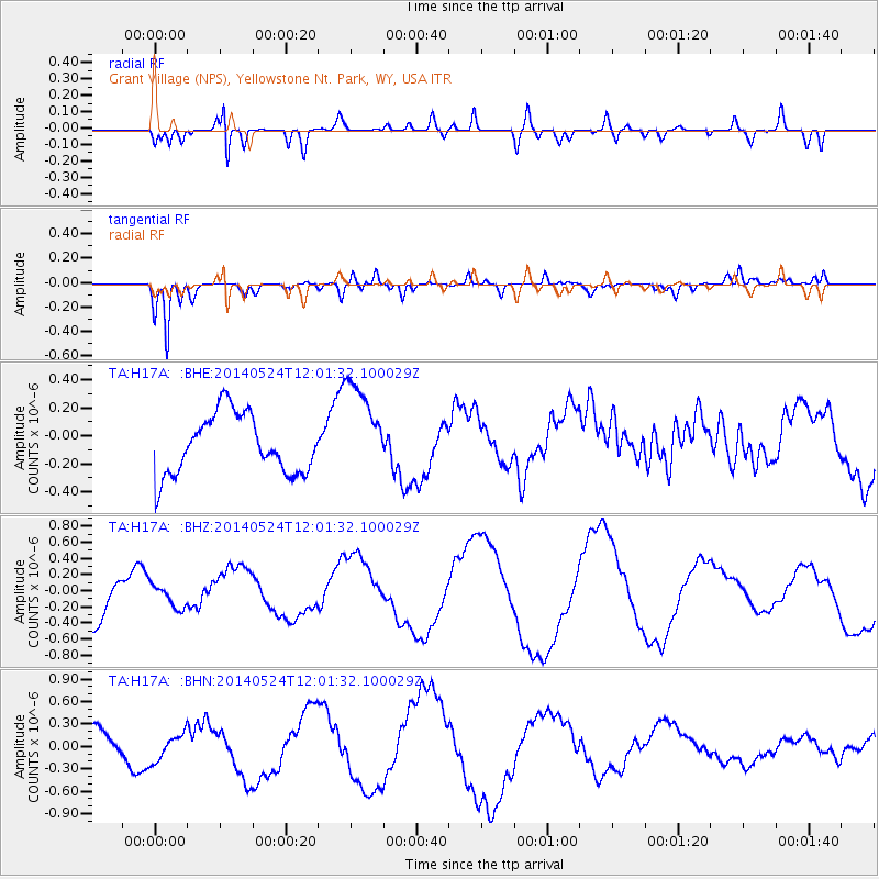
H17A Grant Village (NPS), Yellowstone Nt. Park, WY, USA - Earthquake Result Viewer
*The percent match for this event was below the threshold and hence no stack was calculated.
| Earthquake location: |
Central Mid-Atlantic Ridge |
| Earthquake latitude/longitude: |
0.7/-26.3 |
| Earthquake time(UTC): |
2014/05/24 (144) 11:49:26 GMT |
| Earthquake Depth: |
10 km |
| Earthquake Magnitude: |
5.9 MWC, 5.9 MWC |
| Earthquake Catalog/Contributor: |
NEIC PDE/NEIC COMCAT |
|
| Network: |
TA USArray Transportable Network (new EarthScope stations) |
| Station: |
H17A Grant Village (NPS), Yellowstone Nt. Park, WY, USA |
| Lat/Lon: |
44.40 N/110.58 W |
| Elevation: |
2400 m |
|
| Distance: |
85.4 deg |
| Az: |
314.31 deg |
| Baz: |
93.524 deg |
| Ray Param: |
$rayparam |
*The percent match for this event was below the threshold and hence was not used in the summary stack. |
|
| Radial Match: |
63.57551 % |
| Radial Bump: |
400 |
| Transverse Match: |
77.55094 % |
| Transverse Bump: |
382 |
| SOD ConfigId: |
626651 |
| Insert Time: |
2014-06-22 07:27:07.782 +0000 |
| GWidth: |
2.5 |
| Max Bumps: |
400 |
| Tol: |
0.001 |
|
Signal To Noise
| Channel | StoN | STA | LTA |
| TA:H17A: :BHZ:20140524T12:01:32.100029Z | 0.2871442 | 1.3524192E-7 | 4.7098953E-7 |
| TA:H17A: :BHN:20140524T12:01:32.100029Z | 0.7816873 | 1.8258393E-7 | 2.3357669E-7 |
| TA:H17A: :BHE:20140524T12:01:32.100029Z | 1.6409653 | 3.4570914E-7 | 2.1067424E-7 |
| Arrivals |
| Ps | |
| PpPs | |
| PsPs/PpSs | |


