You are here: Home > Network List > TA - USArray Transportable Network (new EarthScope stations) Stations List
> Station K22A Casper, WY, USA > Earthquake Result Viewer
K22A Casper, WY, USA - Earthquake Result Viewer
| Earthquake location: |
Northern Colombia |
| Earthquake latitude/longitude: |
6.8/-73.0 |
| Earthquake time(UTC): |
2015/03/10 (069) 20:55:43 GMT |
| Earthquake Depth: |
147 km |
| Earthquake Magnitude: |
6.2 MWB |
| Earthquake Catalog/Contributor: |
NEIC PDE/NEIC COMCAT |
|
| Network: |
TA USArray Transportable Network (new EarthScope stations) |
| Station: |
K22A Casper, WY, USA |
| Lat/Lon: |
42.65 N/106.52 W |
| Elevation: |
1686 m |
|
| Distance: |
46.3 deg |
| Az: |
325.726 deg |
| Baz: |
130.713 deg |
| Ray Param: |
0.07017827 |
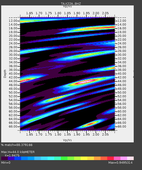
| Estimated Moho Depth: |
44.0 km |
| Estimated Crust Vp/Vs: |
1.95 |
| Assumed Crust Vp: |
6.178 km/s |
| Estimated Crust Vs: |
3.172 km/s |
| Estimated Crust Poisson's Ratio: |
0.32 |
|
| Radial Match: |
88.379166 % |
| Radial Bump: |
400 |
| Transverse Match: |
82.26975 % |
| Transverse Bump: |
385 |
| SOD ConfigId: |
7019011 |
| Insert Time: |
2019-04-17 07:01:46.775 +0000 |
| GWidth: |
2.5 |
| Max Bumps: |
400 |
| Tol: |
0.001 |
|
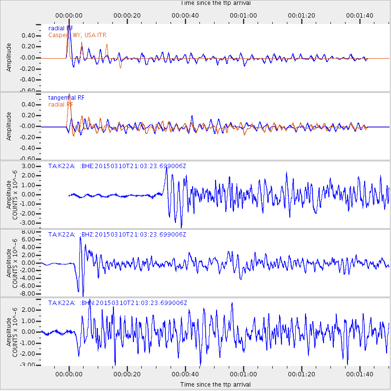
Signal To Noise
| Channel | StoN | STA | LTA |
| TA:K22A: :BHZ:20150310T21:03:23.699006Z | 23.09377 | 3.4903946E-6 | 1.511401E-7 |
| TA:K22A: :BHN:20150310T21:03:23.699006Z | 7.243047 | 8.035741E-7 | 1.109442E-7 |
| TA:K22A: :BHE:20150310T21:03:23.699006Z | 12.89024 | 1.1750066E-6 | 9.1154746E-8 |
| Arrivals |
| Ps | 7.1 SECOND |
| PpPs | 20 SECOND |
| PsPs/PpSs | 27 SECOND |


