You are here: Home > Network List > US - United States National Seismic Network Stations List
> Station AMTX Amarillo, Texas, USA > Earthquake Result Viewer
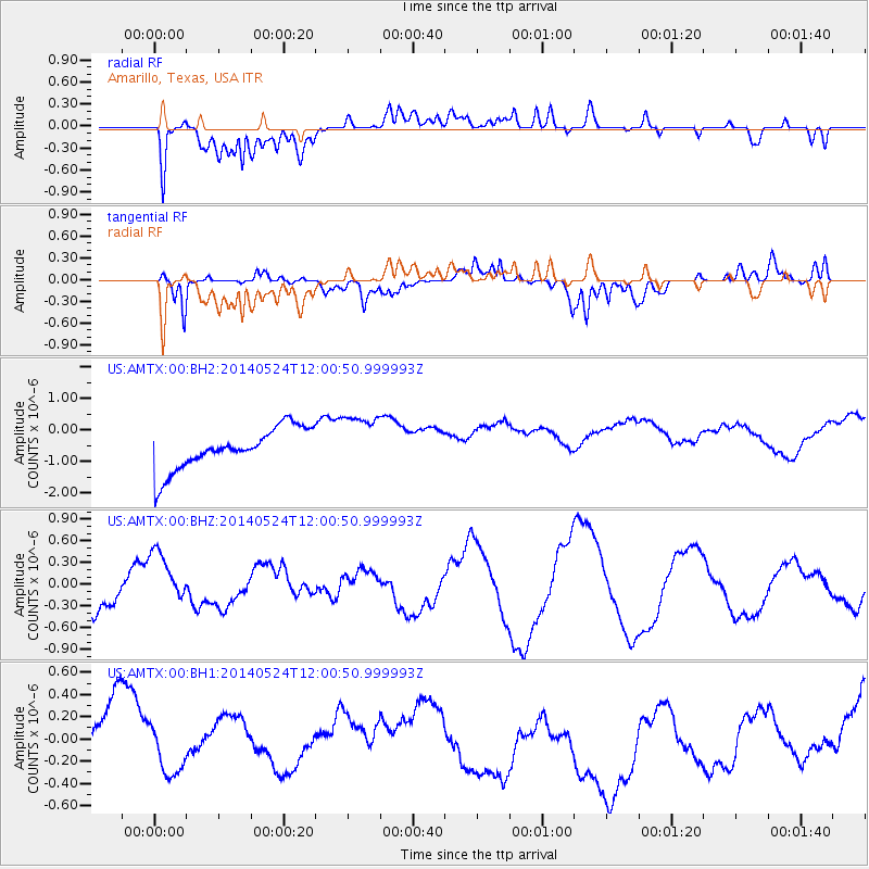
AMTX Amarillo, Texas, USA - Earthquake Result Viewer
*The percent match for this event was below the threshold and hence no stack was calculated.
| Earthquake location: |
Central Mid-Atlantic Ridge |
| Earthquake latitude/longitude: |
0.7/-26.3 |
| Earthquake time(UTC): |
2014/05/24 (144) 11:49:26 GMT |
| Earthquake Depth: |
10 km |
| Earthquake Magnitude: |
5.9 MWC, 5.9 MWC |
| Earthquake Catalog/Contributor: |
NEIC PDE/NEIC COMCAT |
|
| Network: |
US United States National Seismic Network |
| Station: |
AMTX Amarillo, Texas, USA |
| Lat/Lon: |
34.53 N/101.41 W |
| Elevation: |
1010 m |
|
| Distance: |
77.3 deg |
| Az: |
305.148 deg |
| Baz: |
97.977 deg |
| Ray Param: |
$rayparam |
*The percent match for this event was below the threshold and hence was not used in the summary stack. |
|
| Radial Match: |
38.067635 % |
| Radial Bump: |
400 |
| Transverse Match: |
59.965786 % |
| Transverse Bump: |
400 |
| SOD ConfigId: |
626651 |
| Insert Time: |
2014-06-22 07:33:36.495 +0000 |
| GWidth: |
2.5 |
| Max Bumps: |
400 |
| Tol: |
0.001 |
|
Signal To Noise
| Channel | StoN | STA | LTA |
| US:AMTX:00:BHZ:20140524T12:00:50.999993Z | 1.3926544 | 3.9977147E-7 | 2.870572E-7 |
| US:AMTX:00:BH1:20140524T12:00:50.999993Z | 1.0625404 | 2.4668384E-7 | 2.321642E-7 |
| US:AMTX:00:BH2:20140524T12:00:50.999993Z | 1.4938711 | 9.74891E-7 | 6.525938E-7 |
| Arrivals |
| Ps | |
| PpPs | |
| PsPs/PpSs | |


