You are here: Home > Network List > TA - USArray Transportable Network (new EarthScope stations) Stations List
> Station M56A Emporium, PA, USA > Earthquake Result Viewer
M56A Emporium, PA, USA - Earthquake Result Viewer
| Earthquake location: |
Northern Colombia |
| Earthquake latitude/longitude: |
6.8/-73.0 |
| Earthquake time(UTC): |
2015/03/10 (069) 20:55:43 GMT |
| Earthquake Depth: |
147 km |
| Earthquake Magnitude: |
6.2 MWB |
| Earthquake Catalog/Contributor: |
NEIC PDE/NEIC COMCAT |
|
| Network: |
TA USArray Transportable Network (new EarthScope stations) |
| Station: |
M56A Emporium, PA, USA |
| Lat/Lon: |
41.48 N/78.18 W |
| Elevation: |
493 m |
|
| Distance: |
34.8 deg |
| Az: |
353.188 deg |
| Baz: |
170.981 deg |
| Ray Param: |
0.077043846 |
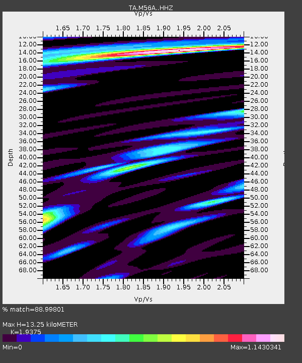
| Estimated Moho Depth: |
13.25 km |
| Estimated Crust Vp/Vs: |
1.94 |
| Assumed Crust Vp: |
6.121 km/s |
| Estimated Crust Vs: |
3.159 km/s |
| Estimated Crust Poisson's Ratio: |
0.32 |
|
| Radial Match: |
88.99801 % |
| Radial Bump: |
400 |
| Transverse Match: |
73.821884 % |
| Transverse Bump: |
400 |
| SOD ConfigId: |
7019011 |
| Insert Time: |
2019-04-17 07:02:12.060 +0000 |
| GWidth: |
2.5 |
| Max Bumps: |
400 |
| Tol: |
0.001 |
|

Signal To Noise
| Channel | StoN | STA | LTA |
| TA:M56A: :HHZ:20150310T21:01:49.700013Z | 38.38689 | 3.9023557E-6 | 1.0165855E-7 |
| TA:M56A: :HHN:20150310T21:01:49.700013Z | 14.932466 | 1.6728208E-6 | 1.1202576E-7 |
| TA:M56A: :HHE:20150310T21:01:49.700013Z | 3.0058537 | 3.691147E-7 | 1.2279862E-7 |
| Arrivals |
| Ps | 2.2 SECOND |
| PpPs | 6.0 SECOND |
| PsPs/PpSs | 8.1 SECOND |


