You are here: Home > Network List > TA - USArray Transportable Network (new EarthScope stations) Stations List
> Station M59A Waymart, PA, USA > Earthquake Result Viewer
M59A Waymart, PA, USA - Earthquake Result Viewer
| Earthquake location: |
Northern Colombia |
| Earthquake latitude/longitude: |
6.8/-73.0 |
| Earthquake time(UTC): |
2015/03/10 (069) 20:55:43 GMT |
| Earthquake Depth: |
147 km |
| Earthquake Magnitude: |
6.2 MWB |
| Earthquake Catalog/Contributor: |
NEIC PDE/NEIC COMCAT |
|
| Network: |
TA USArray Transportable Network (new EarthScope stations) |
| Station: |
M59A Waymart, PA, USA |
| Lat/Lon: |
41.54 N/75.43 W |
| Elevation: |
471 m |
|
| Distance: |
34.6 deg |
| Az: |
356.802 deg |
| Baz: |
175.768 deg |
| Ray Param: |
0.07714056 |
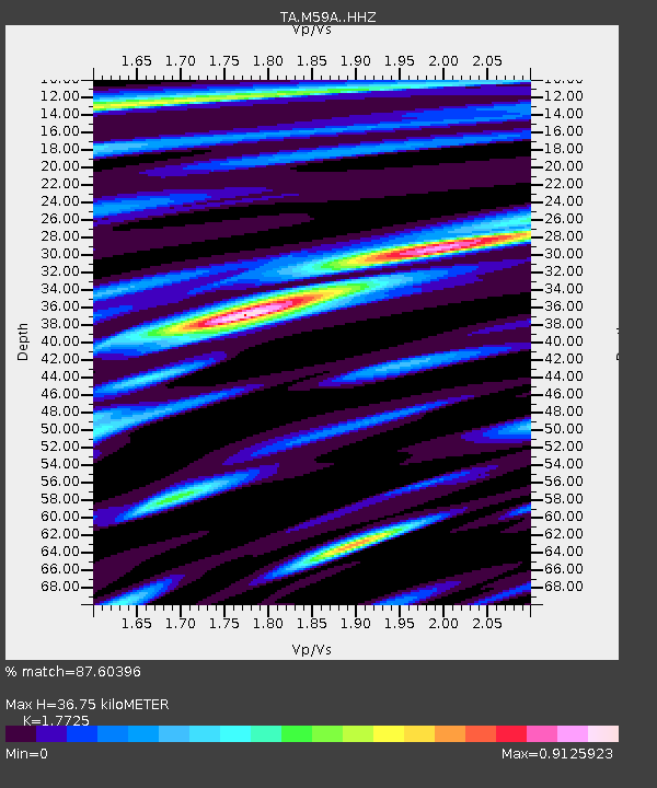
| Estimated Moho Depth: |
36.75 km |
| Estimated Crust Vp/Vs: |
1.77 |
| Assumed Crust Vp: |
6.283 km/s |
| Estimated Crust Vs: |
3.545 km/s |
| Estimated Crust Poisson's Ratio: |
0.27 |
|
| Radial Match: |
87.60396 % |
| Radial Bump: |
320 |
| Transverse Match: |
60.4889 % |
| Transverse Bump: |
400 |
| SOD ConfigId: |
7019011 |
| Insert Time: |
2019-04-17 07:02:14.513 +0000 |
| GWidth: |
2.5 |
| Max Bumps: |
400 |
| Tol: |
0.001 |
|
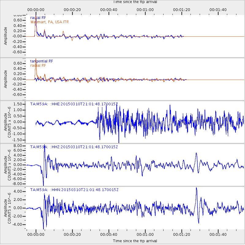
Signal To Noise
| Channel | StoN | STA | LTA |
| TA:M59A: :HHZ:20150310T21:01:48.170015Z | 30.031837 | 3.16399E-6 | 1.0535453E-7 |
| TA:M59A: :HHN:20150310T21:01:48.170015Z | 16.111532 | 1.5926113E-6 | 9.884915E-8 |
| TA:M59A: :HHE:20150310T21:01:48.170015Z | 2.6456637 | 2.7170267E-7 | 1.0269735E-7 |
| Arrivals |
| Ps | 4.9 SECOND |
| PpPs | 15 SECOND |
| PsPs/PpSs | 20 SECOND |


