You are here: Home > Network List > TA - USArray Transportable Network (new EarthScope stations) Stations List
> Station M61A Granite Springs, NY, USA > Earthquake Result Viewer
M61A Granite Springs, NY, USA - Earthquake Result Viewer
| Earthquake location: |
Northern Colombia |
| Earthquake latitude/longitude: |
6.8/-73.0 |
| Earthquake time(UTC): |
2015/03/10 (069) 20:55:43 GMT |
| Earthquake Depth: |
147 km |
| Earthquake Magnitude: |
6.2 MWB |
| Earthquake Catalog/Contributor: |
NEIC PDE/NEIC COMCAT |
|
| Network: |
TA USArray Transportable Network (new EarthScope stations) |
| Station: |
M61A Granite Springs, NY, USA |
| Lat/Lon: |
41.31 N/73.77 W |
| Elevation: |
190 m |
|
| Distance: |
34.3 deg |
| Az: |
358.991 deg |
| Baz: |
178.669 deg |
| Ray Param: |
0.07729405 |
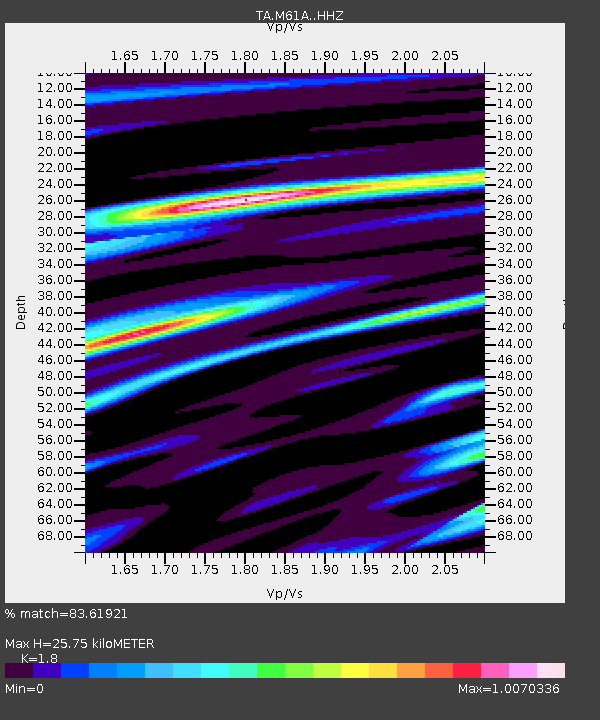
| Estimated Moho Depth: |
25.75 km |
| Estimated Crust Vp/Vs: |
1.80 |
| Assumed Crust Vp: |
6.472 km/s |
| Estimated Crust Vs: |
3.595 km/s |
| Estimated Crust Poisson's Ratio: |
0.28 |
|
| Radial Match: |
83.61921 % |
| Radial Bump: |
351 |
| Transverse Match: |
76.41697 % |
| Transverse Bump: |
400 |
| SOD ConfigId: |
7019011 |
| Insert Time: |
2019-04-17 07:02:16.812 +0000 |
| GWidth: |
2.5 |
| Max Bumps: |
400 |
| Tol: |
0.001 |
|
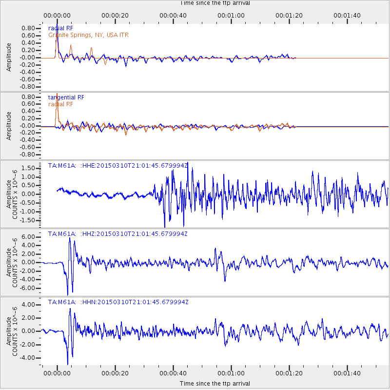
Signal To Noise
| Channel | StoN | STA | LTA |
| TA:M61A: :HHZ:20150310T21:01:45.679994Z | 25.001589 | 2.6667126E-6 | 1.0666172E-7 |
| TA:M61A: :HHN:20150310T21:01:45.679994Z | 7.4819427 | 1.6168154E-6 | 2.1609567E-7 |
| TA:M61A: :HHE:20150310T21:01:45.679994Z | 1.133606 | 1.5753724E-7 | 1.3897002E-7 |
| Arrivals |
| Ps | 3.4 SECOND |
| PpPs | 10 SECOND |
| PsPs/PpSs | 14 SECOND |


