You are here: Home > Network List > TA - USArray Transportable Network (new EarthScope stations) Stations List
> Station N59A State Game Land 141, Hazleton, PA, USA > Earthquake Result Viewer
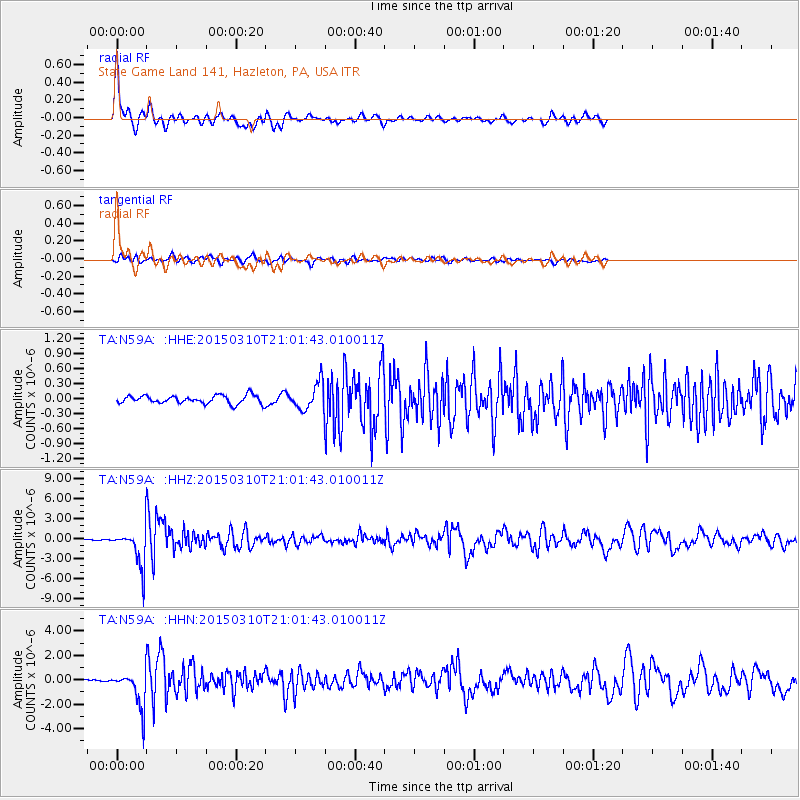
N59A State Game Land 141, Hazleton, PA, USA - Earthquake Result Viewer
| Earthquake location: |
Northern Colombia |
| Earthquake latitude/longitude: |
6.8/-73.0 |
| Earthquake time(UTC): |
2015/03/10 (069) 20:55:43 GMT |
| Earthquake Depth: |
147 km |
| Earthquake Magnitude: |
6.2 MWB |
| Earthquake Catalog/Contributor: |
NEIC PDE/NEIC COMCAT |
|
| Network: |
TA USArray Transportable Network (new EarthScope stations) |
| Station: |
N59A State Game Land 141, Hazleton, PA, USA |
| Lat/Lon: |
40.92 N/75.77 W |
| Elevation: |
508 m |
|
| Distance: |
34.0 deg |
| Az: |
356.263 deg |
| Baz: |
175.101 deg |
| Ray Param: |
0.077452905 |
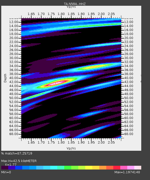
| Estimated Moho Depth: |
42.5 km |
| Estimated Crust Vp/Vs: |
1.77 |
| Assumed Crust Vp: |
6.283 km/s |
| Estimated Crust Vs: |
3.55 km/s |
| Estimated Crust Poisson's Ratio: |
0.27 |
|
| Radial Match: |
87.25719 % |
| Radial Bump: |
246 |
| Transverse Match: |
61.342827 % |
| Transverse Bump: |
307 |
| SOD ConfigId: |
7019011 |
| Insert Time: |
2019-04-17 07:02:27.413 +0000 |
| GWidth: |
2.5 |
| Max Bumps: |
400 |
| Tol: |
0.001 |
|
Signal To Noise
| Channel | StoN | STA | LTA |
| TA:N59A: :HHZ:20150310T21:01:43.010011Z | 31.309376 | 2.7819665E-6 | 8.885411E-8 |
| TA:N59A: :HHN:20150310T21:01:43.010011Z | 18.240396 | 1.5145885E-6 | 8.303484E-8 |
| TA:N59A: :HHE:20150310T21:01:43.010011Z | 3.258456 | 2.603706E-7 | 7.990613E-8 |
| Arrivals |
| Ps | 5.6 SECOND |
| PpPs | 17 SECOND |
| PsPs/PpSs | 23 SECOND |


