You are here: Home > Network List > TA - USArray Transportable Network (new EarthScope stations) Stations List
> Station N61A South Mountain, Millburn, NJ, USA > Earthquake Result Viewer
N61A South Mountain, Millburn, NJ, USA - Earthquake Result Viewer
| Earthquake location: |
Northern Colombia |
| Earthquake latitude/longitude: |
6.8/-73.0 |
| Earthquake time(UTC): |
2015/03/10 (069) 20:55:43 GMT |
| Earthquake Depth: |
147 km |
| Earthquake Magnitude: |
6.2 MWB |
| Earthquake Catalog/Contributor: |
NEIC PDE/NEIC COMCAT |
|
| Network: |
TA USArray Transportable Network (new EarthScope stations) |
| Station: |
N61A South Mountain, Millburn, NJ, USA |
| Lat/Lon: |
40.75 N/74.30 W |
| Elevation: |
108 m |
|
| Distance: |
33.8 deg |
| Az: |
358.244 deg |
| Baz: |
177.705 deg |
| Ray Param: |
0.077572934 |
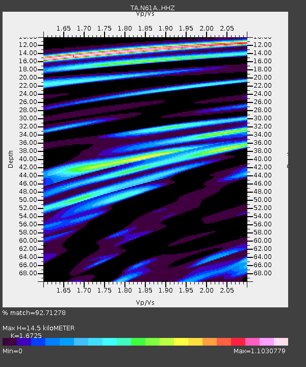
| Estimated Moho Depth: |
14.5 km |
| Estimated Crust Vp/Vs: |
1.67 |
| Assumed Crust Vp: |
6.283 km/s |
| Estimated Crust Vs: |
3.757 km/s |
| Estimated Crust Poisson's Ratio: |
0.22 |
|
| Radial Match: |
92.71278 % |
| Radial Bump: |
303 |
| Transverse Match: |
85.63144 % |
| Transverse Bump: |
400 |
| SOD ConfigId: |
7019011 |
| Insert Time: |
2019-04-17 07:02:30.310 +0000 |
| GWidth: |
2.5 |
| Max Bumps: |
400 |
| Tol: |
0.001 |
|

Signal To Noise
| Channel | StoN | STA | LTA |
| TA:N61A: :HHZ:20150310T21:01:41.000001Z | 24.95725 | 3.274603E-6 | 1.3120848E-7 |
| TA:N61A: :HHN:20150310T21:01:41.000001Z | 16.95472 | 1.8752532E-6 | 1.1060361E-7 |
| TA:N61A: :HHE:20150310T21:01:41.000001Z | 6.562308 | 7.009141E-7 | 1.0680909E-7 |
| Arrivals |
| Ps | 1.7 SECOND |
| PpPs | 5.7 SECOND |
| PsPs/PpSs | 7.4 SECOND |


