You are here: Home > Network List > TA - USArray Transportable Network (new EarthScope stations) Stations List
> Station O03E Paynes Creek, CA, USA > Earthquake Result Viewer
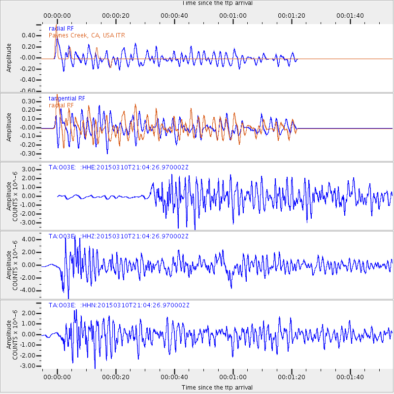
O03E Paynes Creek, CA, USA - Earthquake Result Viewer
*The percent match for this event was below the threshold and hence no stack was calculated.
| Earthquake location: |
Northern Colombia |
| Earthquake latitude/longitude: |
6.8/-73.0 |
| Earthquake time(UTC): |
2015/03/10 (069) 20:55:43 GMT |
| Earthquake Depth: |
147 km |
| Earthquake Magnitude: |
6.2 MWB |
| Earthquake Catalog/Contributor: |
NEIC PDE/NEIC COMCAT |
|
| Network: |
TA USArray Transportable Network (new EarthScope stations) |
| Station: |
O03E Paynes Creek, CA, USA |
| Lat/Lon: |
40.29 N/121.80 W |
| Elevation: |
967 m |
|
| Distance: |
54.8 deg |
| Az: |
315.236 deg |
| Baz: |
113.904 deg |
| Ray Param: |
$rayparam |
*The percent match for this event was below the threshold and hence was not used in the summary stack. |
|
| Radial Match: |
72.001785 % |
| Radial Bump: |
400 |
| Transverse Match: |
76.91129 % |
| Transverse Bump: |
400 |
| SOD ConfigId: |
7019011 |
| Insert Time: |
2019-04-17 07:02:33.672 +0000 |
| GWidth: |
2.5 |
| Max Bumps: |
400 |
| Tol: |
0.001 |
|
Signal To Noise
| Channel | StoN | STA | LTA |
| TA:O03E: :HHZ:20150310T21:04:26.970002Z | 21.749754 | 2.0891239E-6 | 9.605276E-8 |
| TA:O03E: :HHN:20150310T21:04:26.970002Z | 3.2827377 | 5.2357507E-7 | 1.5949342E-7 |
| TA:O03E: :HHE:20150310T21:04:26.970002Z | 5.0926404 | 6.2607296E-7 | 1.2293681E-7 |
| Arrivals |
| Ps | |
| PpPs | |
| PsPs/PpSs | |


