You are here: Home > Network List > TA - USArray Transportable Network (new EarthScope stations) Stations List
> Station O57A Amberson, PA, USA > Earthquake Result Viewer
O57A Amberson, PA, USA - Earthquake Result Viewer
| Earthquake location: |
Northern Colombia |
| Earthquake latitude/longitude: |
6.8/-73.0 |
| Earthquake time(UTC): |
2015/03/10 (069) 20:55:43 GMT |
| Earthquake Depth: |
147 km |
| Earthquake Magnitude: |
6.2 MWB |
| Earthquake Catalog/Contributor: |
NEIC PDE/NEIC COMCAT |
|
| Network: |
TA USArray Transportable Network (new EarthScope stations) |
| Station: |
O57A Amberson, PA, USA |
| Lat/Lon: |
40.21 N/77.64 W |
| Elevation: |
377 m |
|
| Distance: |
33.5 deg |
| Az: |
353.577 deg |
| Baz: |
171.66 deg |
| Ray Param: |
0.077727795 |
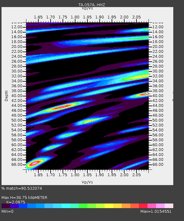
| Estimated Moho Depth: |
38.75 km |
| Estimated Crust Vp/Vs: |
2.10 |
| Assumed Crust Vp: |
6.121 km/s |
| Estimated Crust Vs: |
2.918 km/s |
| Estimated Crust Poisson's Ratio: |
0.35 |
|
| Radial Match: |
90.532074 % |
| Radial Bump: |
342 |
| Transverse Match: |
78.979355 % |
| Transverse Bump: |
400 |
| SOD ConfigId: |
7019011 |
| Insert Time: |
2019-04-17 07:02:36.794 +0000 |
| GWidth: |
2.5 |
| Max Bumps: |
400 |
| Tol: |
0.001 |
|
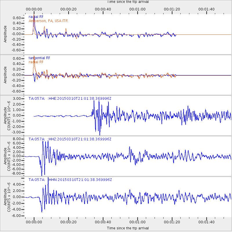
Signal To Noise
| Channel | StoN | STA | LTA |
| TA:O57A: :HHZ:20150310T21:01:38.369996Z | 21.310276 | 2.6792018E-6 | 1.2572347E-7 |
| TA:O57A: :HHN:20150310T21:01:38.369996Z | 15.275524 | 1.4252961E-6 | 9.330587E-8 |
| TA:O57A: :HHE:20150310T21:01:38.369996Z | 7.9512987 | 4.6389255E-7 | 5.8341733E-8 |
| Arrivals |
| Ps | 7.4 SECOND |
| PpPs | 19 SECOND |
| PsPs/PpSs | 26 SECOND |


