You are here: Home > Network List > TA - USArray Transportable Network (new EarthScope stations) Stations List
> Station Q59A Harwood, MD, USA > Earthquake Result Viewer
Q59A Harwood, MD, USA - Earthquake Result Viewer
| Earthquake location: |
Northern Colombia |
| Earthquake latitude/longitude: |
6.8/-73.0 |
| Earthquake time(UTC): |
2015/03/10 (069) 20:55:43 GMT |
| Earthquake Depth: |
147 km |
| Earthquake Magnitude: |
6.2 MWB |
| Earthquake Catalog/Contributor: |
NEIC PDE/NEIC COMCAT |
|
| Network: |
TA USArray Transportable Network (new EarthScope stations) |
| Station: |
Q59A Harwood, MD, USA |
| Lat/Lon: |
38.86 N/76.65 W |
| Elevation: |
34 m |
|
| Distance: |
32.1 deg |
| Az: |
354.638 deg |
| Baz: |
173.173 deg |
| Ray Param: |
0.078389 |
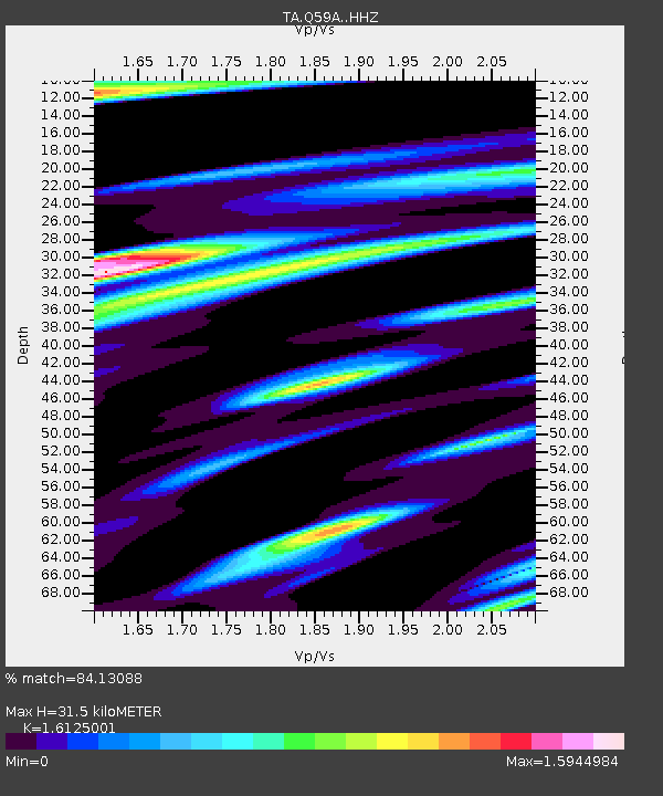
| Estimated Moho Depth: |
31.5 km |
| Estimated Crust Vp/Vs: |
1.61 |
| Assumed Crust Vp: |
6.419 km/s |
| Estimated Crust Vs: |
3.981 km/s |
| Estimated Crust Poisson's Ratio: |
0.19 |
|
| Radial Match: |
84.13088 % |
| Radial Bump: |
325 |
| Transverse Match: |
72.20218 % |
| Transverse Bump: |
381 |
| SOD ConfigId: |
7019011 |
| Insert Time: |
2019-04-17 07:02:48.677 +0000 |
| GWidth: |
2.5 |
| Max Bumps: |
400 |
| Tol: |
0.001 |
|
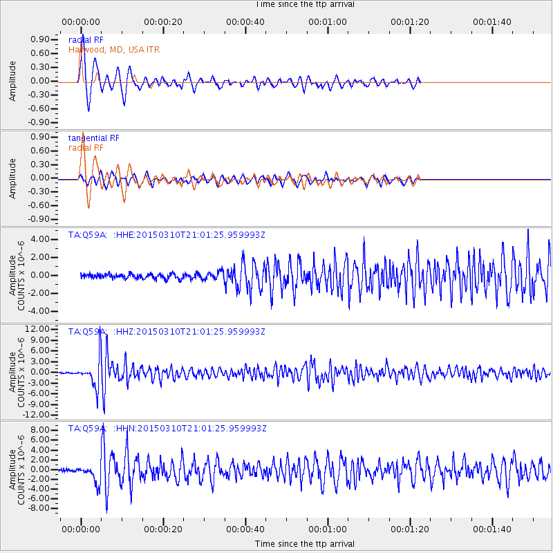
Signal To Noise
| Channel | StoN | STA | LTA |
| TA:Q59A: :HHZ:20150310T21:01:25.959993Z | 30.069056 | 4.19128E-6 | 1.3938848E-7 |
| TA:Q59A: :HHN:20150310T21:01:25.959993Z | 9.429122 | 1.8537528E-6 | 1.9659866E-7 |
| TA:Q59A: :HHE:20150310T21:01:25.959993Z | 1.7077347 | 4.179318E-7 | 2.4472877E-7 |
| Arrivals |
| Ps | 3.3 SECOND |
| PpPs | 12 SECOND |
| PsPs/PpSs | 15 SECOND |


