You are here: Home > Network List > TA - USArray Transportable Network (new EarthScope stations) Stations List
> Station S57A Dark Hollow, Roseland, VA, USA > Earthquake Result Viewer
S57A Dark Hollow, Roseland, VA, USA - Earthquake Result Viewer

| Earthquake location: |
Northern Colombia |
| Earthquake latitude/longitude: |
6.8/-73.0 |
| Earthquake time(UTC): |
2015/03/10 (069) 20:55:43 GMT |
| Earthquake Depth: |
147 km |
| Earthquake Magnitude: |
6.2 MWB |
| Earthquake Catalog/Contributor: |
NEIC PDE/NEIC COMCAT |
|
| Network: |
TA USArray Transportable Network (new EarthScope stations) |
| Station: |
S57A Dark Hollow, Roseland, VA, USA |
| Lat/Lon: |
37.76 N/78.95 W |
| Elevation: |
264 m |
|
| Distance: |
31.3 deg |
| Az: |
350.903 deg |
| Baz: |
168.575 deg |
| Ray Param: |
0.07873114 |
| Estimated Moho Depth: |
50.25 km |
| Estimated Crust Vp/Vs: |
1.69 |
| Assumed Crust Vp: |
6.419 km/s |
| Estimated Crust Vs: |
3.804 km/s |
| Estimated Crust Poisson's Ratio: |
0.23 |
|
| Radial Match: |
87.45602 % |
| Radial Bump: |
381 |
| Transverse Match: |
69.698204 % |
| Transverse Bump: |
393 |
| SOD ConfigId: |
7019011 |
| Insert Time: |
2019-04-17 07:02:59.731 +0000 |
| GWidth: |
2.5 |
| Max Bumps: |
400 |
| Tol: |
0.001 |
|
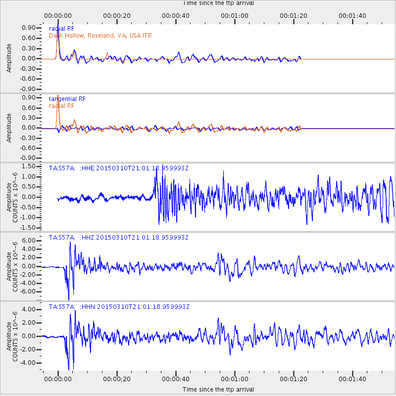
Signal To Noise
| Channel | StoN | STA | LTA |
| TA:S57A: :HHZ:20150310T21:01:18.959993Z | 27.466442 | 2.5114036E-6 | 9.1435346E-8 |
| TA:S57A: :HHN:20150310T21:01:18.959993Z | 19.400845 | 1.6739593E-6 | 8.62828E-8 |
| TA:S57A: :HHE:20150310T21:01:18.959993Z | 5.8827186 | 4.921663E-7 | 8.366307E-8 |
| Arrivals |
| Ps | 5.8 SECOND |
| PpPs | 19 SECOND |
| PsPs/PpSs | 25 SECOND |


