You are here: Home > Network List > TA - USArray Transportable Network (new EarthScope stations) Stations List
> Station Q53A Leroy, WV, USA > Earthquake Result Viewer
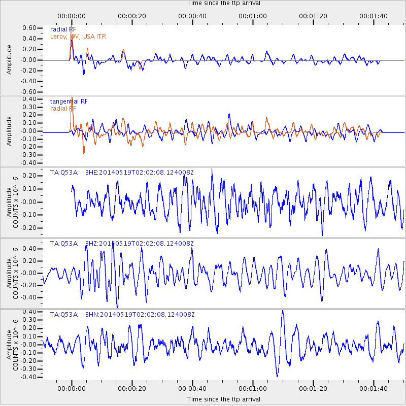
Q53A Leroy, WV, USA - Earthquake Result Viewer
*The percent match for this event was below the threshold and hence no stack was calculated.
| Earthquake location: |
Central East Pacific Rise |
| Earthquake latitude/longitude: |
-4.8/-105.5 |
| Earthquake time(UTC): |
2014/05/19 (139) 01:53:54 GMT |
| Earthquake Depth: |
10 km |
| Earthquake Magnitude: |
5.5 MWB, 5.6 MWC |
| Earthquake Catalog/Contributor: |
NEIC PDE/NEIC COMCAT |
|
| Network: |
TA USArray Transportable Network (new EarthScope stations) |
| Station: |
Q53A Leroy, WV, USA |
| Lat/Lon: |
38.86 N/81.53 W |
| Elevation: |
310 m |
|
| Distance: |
48.8 deg |
| Az: |
24.999 deg |
| Baz: |
212.645 deg |
| Ray Param: |
$rayparam |
*The percent match for this event was below the threshold and hence was not used in the summary stack. |
|
| Radial Match: |
67.07525 % |
| Radial Bump: |
400 |
| Transverse Match: |
65.49083 % |
| Transverse Bump: |
400 |
| SOD ConfigId: |
626651 |
| Insert Time: |
2014-06-25 19:11:04.761 +0000 |
| GWidth: |
2.5 |
| Max Bumps: |
400 |
| Tol: |
0.001 |
|
Signal To Noise
| Channel | StoN | STA | LTA |
| TA:Q53A: :BHZ:20140519T02:02:08.124008Z | 2.2596664 | 1.9747976E-7 | 8.7393325E-8 |
| TA:Q53A: :BHN:20140519T02:02:08.124008Z | 1.5166996 | 1.2122253E-7 | 7.992521E-8 |
| TA:Q53A: :BHE:20140519T02:02:08.124008Z | 1.3709772 | 8.888986E-8 | 6.483687E-8 |
| Arrivals |
| Ps | |
| PpPs | |
| PsPs/PpSs | |


