You are here: Home > Network List > TA - USArray Transportable Network (new EarthScope stations) Stations List
> Station T57A Hurt, VA, USA > Earthquake Result Viewer
T57A Hurt, VA, USA - Earthquake Result Viewer
| Earthquake location: |
Northern Colombia |
| Earthquake latitude/longitude: |
6.8/-73.0 |
| Earthquake time(UTC): |
2015/03/10 (069) 20:55:43 GMT |
| Earthquake Depth: |
147 km |
| Earthquake Magnitude: |
6.2 MWB |
| Earthquake Catalog/Contributor: |
NEIC PDE/NEIC COMCAT |
|
| Network: |
TA USArray Transportable Network (new EarthScope stations) |
| Station: |
T57A Hurt, VA, USA |
| Lat/Lon: |
37.00 N/79.25 W |
| Elevation: |
230 m |
|
| Distance: |
30.6 deg |
| Az: |
350.144 deg |
| Baz: |
167.742 deg |
| Ray Param: |
0.07902435 |
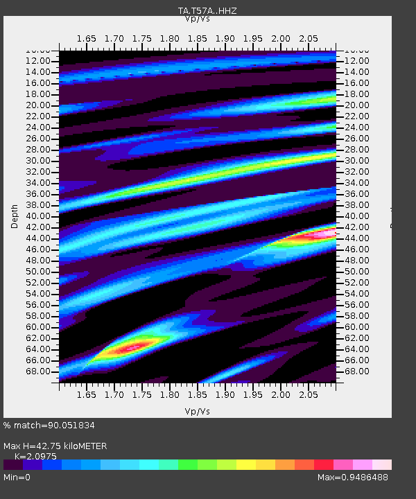
| Estimated Moho Depth: |
42.75 km |
| Estimated Crust Vp/Vs: |
2.10 |
| Assumed Crust Vp: |
6.419 km/s |
| Estimated Crust Vs: |
3.06 km/s |
| Estimated Crust Poisson's Ratio: |
0.35 |
|
| Radial Match: |
90.051834 % |
| Radial Bump: |
328 |
| Transverse Match: |
64.90237 % |
| Transverse Bump: |
399 |
| SOD ConfigId: |
7019011 |
| Insert Time: |
2019-04-17 07:03:05.658 +0000 |
| GWidth: |
2.5 |
| Max Bumps: |
400 |
| Tol: |
0.001 |
|
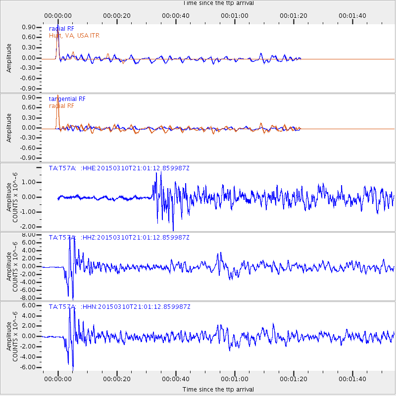
Signal To Noise
| Channel | StoN | STA | LTA |
| TA:T57A: :HHZ:20150310T21:01:12.859987Z | 33.384357 | 2.6599894E-6 | 7.967772E-8 |
| TA:T57A: :HHN:20150310T21:01:12.859987Z | 28.94808 | 1.8591821E-6 | 6.4224714E-8 |
| TA:T57A: :HHE:20150310T21:01:12.859987Z | 7.3259354 | 5.505072E-7 | 7.514497E-8 |
| Arrivals |
| Ps | 7.8 SECOND |
| PpPs | 19 SECOND |
| PsPs/PpSs | 27 SECOND |


