You are here: Home > Network List > TA - USArray Transportable Network (new EarthScope stations) Stations List
> Station TPFO Pinon Flats, CA, USA > Earthquake Result Viewer
TPFO Pinon Flats, CA, USA - Earthquake Result Viewer
| Earthquake location: |
Northern Colombia |
| Earthquake latitude/longitude: |
6.8/-73.0 |
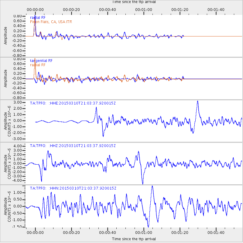
| Earthquake time(UTC): |
2015/03/10 (069) 20:55:43 GMT |
| Earthquake Depth: |
147 km |
| Earthquake Magnitude: |
6.2 MWB |
| Earthquake Catalog/Contributor: |
NEIC PDE/NEIC COMCAT |
|
| Network: |
TA USArray Transportable Network (new EarthScope stations) |
| Station: |
TPFO Pinon Flats, CA, USA |
| Lat/Lon: |
33.61 N/116.45 W |
| Elevation: |
1275 m |
|
| Distance: |
48.2 deg |
| Az: |
309.644 deg |
| Baz: |
113.623 deg |
| Ray Param: |
0.06899344 |
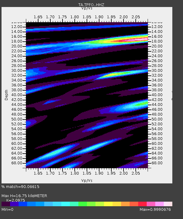
| Estimated Moho Depth: |
16.75 km |
| Estimated Crust Vp/Vs: |
2.10 |
| Assumed Crust Vp: |
6.264 km/s |
| Estimated Crust Vs: |
2.986 km/s |
| Estimated Crust Poisson's Ratio: |
0.35 |
|
| Radial Match: |
90.06615 % |
| Radial Bump: |
400 |
| Transverse Match: |
80.98709 % |
| Transverse Bump: |
400 |
| SOD ConfigId: |
7019011 |
| Insert Time: |
2019-04-17 07:03:10.794 +0000 |
| GWidth: |
2.5 |
| Max Bumps: |
400 |
| Tol: |
0.001 |
|
Signal To Noise
| Channel | StoN | STA | LTA |
| TA:TPFO: :HHZ:20150310T21:03:37.920015Z | 10.37199 | 1.3036057E-6 | 1.256852E-7 |
| TA:TPFO: :HHN:20150310T21:03:37.920015Z | 2.4307115 | 3.4363225E-7 | 1.4137106E-7 |
| TA:TPFO: :HHE:20150310T21:03:37.920015Z | 7.5500445 | 8.0988445E-7 | 1.0726883E-7 |
| Arrivals |
| Ps | 3.1 SECOND |
| PpPs | 7.9 SECOND |
| PsPs/PpSs | 11 SECOND |


