You are here: Home > Network List > TD - TransAlta Monitoring Network Stations List
> Station TD016 Z > Earthquake Result Viewer
TD016 Z - Earthquake Result Viewer
| Earthquake location: |
Northern Colombia |
| Earthquake latitude/longitude: |
6.8/-73.0 |
| Earthquake time(UTC): |
2015/03/10 (069) 20:55:43 GMT |
| Earthquake Depth: |
147 km |
| Earthquake Magnitude: |
6.2 MWB |
| Earthquake Catalog/Contributor: |
NEIC PDE/NEIC COMCAT |
|
| Network: |
TD TransAlta Monitoring Network |
| Station: |
TD016 Z |
| Lat/Lon: |
51.21 N/114.84 W |
| Elevation: |
1380 m |
|
| Distance: |
56.1 deg |
| Az: |
329.658 deg |
| Baz: |
127.11 deg |
| Ray Param: |
0.063866474 |
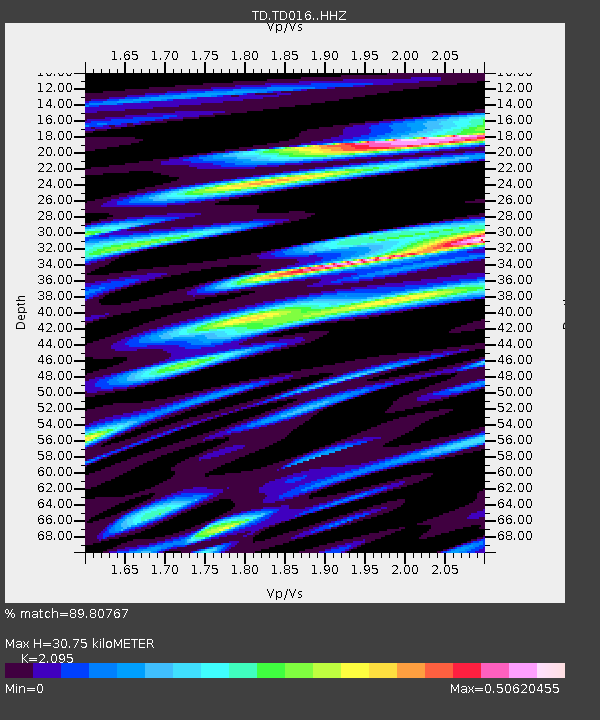
| Estimated Moho Depth: |
30.75 km |
| Estimated Crust Vp/Vs: |
2.10 |
| Assumed Crust Vp: |
6.178 km/s |
| Estimated Crust Vs: |
2.949 km/s |
| Estimated Crust Poisson's Ratio: |
0.35 |
|
| Radial Match: |
89.80767 % |
| Radial Bump: |
400 |
| Transverse Match: |
83.06162 % |
| Transverse Bump: |
400 |
| SOD ConfigId: |
7019011 |
| Insert Time: |
2019-04-17 07:03:26.674 +0000 |
| GWidth: |
2.5 |
| Max Bumps: |
400 |
| Tol: |
0.001 |
|

Signal To Noise
| Channel | StoN | STA | LTA |
| TD:TD016: :HHZ:20150310T21:04:36.54001Z | 27.3674 | 4.411588E-6 | 1.6119866E-7 |
| TD:TD016: :HH1:20150310T21:04:36.54001Z | 7.540031 | 9.169181E-7 | 1.2160667E-7 |
| TD:TD016: :HH2:20150310T21:04:36.54001Z | 20.334332 | 1.6571433E-6 | 8.149485E-8 |
| Arrivals |
| Ps | 5.7 SECOND |
| PpPs | 15 SECOND |
| PsPs/PpSs | 20 SECOND |


