You are here: Home > Network List > TO - Tectonic Observatory Stations List
> Station CC33 CCSE CC33 > Earthquake Result Viewer
CC33 CCSE CC33 - Earthquake Result Viewer
| Earthquake location: |
Northern Colombia |
| Earthquake latitude/longitude: |
6.8/-73.0 |
| Earthquake time(UTC): |
2015/03/10 (069) 20:55:43 GMT |
| Earthquake Depth: |
147 km |
| Earthquake Magnitude: |
6.2 MWB |
| Earthquake Catalog/Contributor: |
NEIC PDE/NEIC COMCAT |
|
| Network: |
TO Tectonic Observatory |
| Station: |
CC33 CCSE CC33 |
| Lat/Lon: |
36.34 N/119.12 W |
| Elevation: |
126 m |
|
| Distance: |
51.3 deg |
| Az: |
311.778 deg |
| Baz: |
113.479 deg |
| Ray Param: |
0.06700499 |
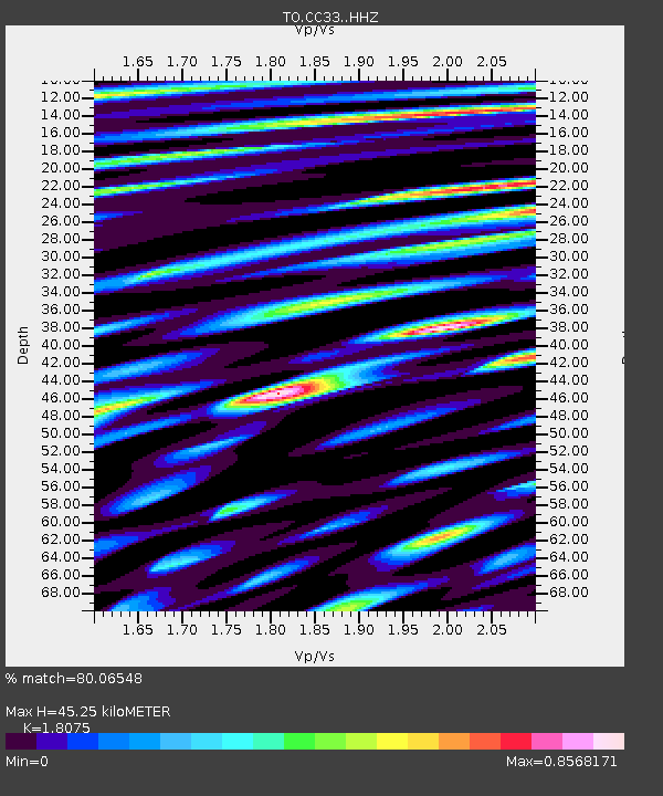
| Estimated Moho Depth: |
45.25 km |
| Estimated Crust Vp/Vs: |
1.81 |
| Assumed Crust Vp: |
6.291 km/s |
| Estimated Crust Vs: |
3.481 km/s |
| Estimated Crust Poisson's Ratio: |
0.28 |
|
| Radial Match: |
80.06548 % |
| Radial Bump: |
400 |
| Transverse Match: |
60.26854 % |
| Transverse Bump: |
400 |
| SOD ConfigId: |
7019011 |
| Insert Time: |
2019-04-17 07:03:46.214 +0000 |
| GWidth: |
2.5 |
| Max Bumps: |
400 |
| Tol: |
0.001 |
|

Signal To Noise
| Channel | StoN | STA | LTA |
| TO:CC33: :HHZ:20150310T21:04:01.29001Z | 15.101215 | 1.9377424E-6 | 1.2831697E-7 |
| TO:CC33: :HHN:20150310T21:04:01.29001Z | 3.1515458 | 4.9497106E-7 | 1.5705662E-7 |
| TO:CC33: :HHE:20150310T21:04:01.29001Z | 6.407306 | 8.5780897E-7 | 1.3387981E-7 |
| Arrivals |
| Ps | 6.1 SECOND |
| PpPs | 19 SECOND |
| PsPs/PpSs | 25 SECOND |


