You are here: Home > Network List > TO - Tectonic Observatory Stations List
> Station CC36 CCSE CC36 > Earthquake Result Viewer
CC36 CCSE CC36 - Earthquake Result Viewer
| Earthquake location: |
Northern Colombia |
| Earthquake latitude/longitude: |
6.8/-73.0 |
| Earthquake time(UTC): |
2015/03/10 (069) 20:55:43 GMT |
| Earthquake Depth: |
147 km |
| Earthquake Magnitude: |
6.2 MWB |
| Earthquake Catalog/Contributor: |
NEIC PDE/NEIC COMCAT |
|
| Network: |
TO Tectonic Observatory |
| Station: |
CC36 CCSE CC36 |
| Lat/Lon: |
36.39 N/118.96 W |
| Elevation: |
265 m |
|
| Distance: |
51.2 deg |
| Az: |
311.897 deg |
| Baz: |
113.649 deg |
| Ray Param: |
0.06707122 |
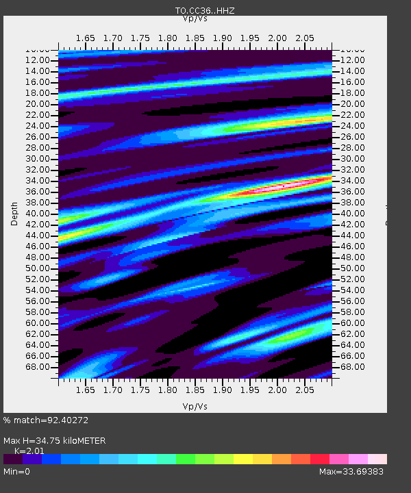
| Estimated Moho Depth: |
34.75 km |
| Estimated Crust Vp/Vs: |
2.01 |
| Assumed Crust Vp: |
6.291 km/s |
| Estimated Crust Vs: |
3.13 km/s |
| Estimated Crust Poisson's Ratio: |
0.34 |
|
| Radial Match: |
92.40272 % |
| Radial Bump: |
400 |
| Transverse Match: |
92.40272 % |
| Transverse Bump: |
400 |
| SOD ConfigId: |
7019011 |
| Insert Time: |
2019-04-17 07:03:47.114 +0000 |
| GWidth: |
2.5 |
| Max Bumps: |
400 |
| Tol: |
0.001 |
|

Signal To Noise
| Channel | StoN | STA | LTA |
| TO:CC36: :HHZ:20150310T21:04:00.54001Z | 28.591059 | 6.819783E-8 | 2.385285E-9 |
| $trig.getChannelId() | $trig.getValue() | $trig.getSTA() | $trig.getLTA() |
| TO:CC36: :HHE:20150310T21:04:00.54001Z | 7.9361043 | 7.6096313E-7 | 9.5886236E-8 |
| Arrivals |
| Ps | 5.8 SECOND |
| PpPs | 16 SECOND |
| PsPs/PpSs | 22 SECOND |


