You are here: Home > Network List > TA - USArray Transportable Network (new EarthScope stations) Stations List
> Station Z41A Richland Creek Farm, El Dorado, AR, USA > Earthquake Result Viewer
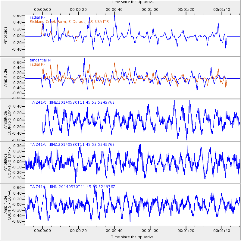
Z41A Richland Creek Farm, El Dorado, AR, USA - Earthquake Result Viewer
*The percent match for this event was below the threshold and hence no stack was calculated.
| Earthquake location: |
Pacific-Antarctic Ridge |
| Earthquake latitude/longitude: |
-55.3/-128.6 |
| Earthquake time(UTC): |
2014/05/30 (150) 11:33:10 GMT |
| Earthquake Depth: |
11 km |
| Earthquake Magnitude: |
5.5 MWC, 5.5 MWB, 5.5 MWC |
| Earthquake Catalog/Contributor: |
NEIC PDE/NEIC COMCAT |
|
| Network: |
TA USArray Transportable Network (new EarthScope stations) |
| Station: |
Z41A Richland Creek Farm, El Dorado, AR, USA |
| Lat/Lon: |
33.26 N/92.80 W |
| Elevation: |
62 m |
|
| Distance: |
93.4 deg |
| Az: |
29.384 deg |
| Baz: |
199.559 deg |
| Ray Param: |
$rayparam |
*The percent match for this event was below the threshold and hence was not used in the summary stack. |
|
| Radial Match: |
45.386818 % |
| Radial Bump: |
281 |
| Transverse Match: |
63.99284 % |
| Transverse Bump: |
395 |
| SOD ConfigId: |
739768 |
| Insert Time: |
2014-06-27 09:21:34.333 +0000 |
| GWidth: |
2.5 |
| Max Bumps: |
400 |
| Tol: |
0.001 |
|
Signal To Noise
| Channel | StoN | STA | LTA |
| TA:Z41A: :BHZ:20140530T11:45:53.524976Z | 1.0927174 | 8.723465E-8 | 7.983277E-8 |
| TA:Z41A: :BHN:20140530T11:45:53.524976Z | 2.2918026 | 3.6981564E-7 | 1.6136453E-7 |
| TA:Z41A: :BHE:20140530T11:45:53.524976Z | 0.6397507 | 1.4112493E-7 | 2.2059362E-7 |
| Arrivals |
| Ps | |
| PpPs | |
| PsPs/PpSs | |


