You are here: Home > Network List > WI - West Indies IPGP Network Stations List
> Station BIM Morne Bigot, Anses d'Arlets, Martinique > Earthquake Result Viewer
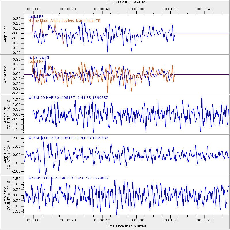
BIM Morne Bigot, Anses d'Arlets, Martinique - Earthquake Result Viewer
*The percent match for this event was below the threshold and hence no stack was calculated.
| Earthquake location: |
Southern Mid-Atlantic Ridge |
| Earthquake latitude/longitude: |
-46.0/-13.9 |
| Earthquake time(UTC): |
2014/06/13 (164) 19:30:30 GMT |
| Earthquake Depth: |
10 km |
| Earthquake Magnitude: |
5.7 MB, 5.6 MWB, 5.8 MWC |
| Earthquake Catalog/Contributor: |
NEIC PDE/NEIC COMCAT |
|
| Network: |
WI West Indies IPGP Network |
| Station: |
BIM Morne Bigot, Anses d'Arlets, Martinique |
| Lat/Lon: |
14.52 N/61.07 W |
| Elevation: |
391 m |
|
| Distance: |
73.8 deg |
| Az: |
312.254 deg |
| Baz: |
147.828 deg |
| Ray Param: |
$rayparam |
*The percent match for this event was below the threshold and hence was not used in the summary stack. |
|
| Radial Match: |
60.87023 % |
| Radial Bump: |
400 |
| Transverse Match: |
57.55338 % |
| Transverse Bump: |
400 |
| SOD ConfigId: |
739768 |
| Insert Time: |
2014-06-27 19:42:21.513 +0000 |
| GWidth: |
2.5 |
| Max Bumps: |
400 |
| Tol: |
0.001 |
|
Signal To Noise
| Channel | StoN | STA | LTA |
| WI:BIM:00:HHZ:20140613T19:41:33.139983Z | 2.7900522 | 9.282602E-7 | 3.327035E-7 |
| WI:BIM:00:HHN:20140613T19:41:33.139983Z | 1.6007398 | 6.77657E-7 | 4.2333986E-7 |
| WI:BIM:00:HHE:20140613T19:41:33.139983Z | 1.4653187 | 7.840505E-7 | 5.3507165E-7 |
| Arrivals |
| Ps | |
| PpPs | |
| PsPs/PpSs | |


