You are here: Home > Network List > XD14 - Illuminating the architecture of the greater Mount St. Helens magmatic systems f Stations List
> Station MN07 "Mount St Helens, WA" > Earthquake Result Viewer
MN07 "Mount St Helens, WA" - Earthquake Result Viewer
| Earthquake location: |
Northern Colombia |
| Earthquake latitude/longitude: |
6.8/-73.0 |
| Earthquake time(UTC): |
2015/03/10 (069) 20:55:43 GMT |
| Earthquake Depth: |
147 km |
| Earthquake Magnitude: |
6.2 MWB |
| Earthquake Catalog/Contributor: |
NEIC PDE/NEIC COMCAT |
|
| Network: |
XD Illuminating the architecture of the greater Mount St. Helens magmatic systems f |
| Station: |
MN07 "Mount St Helens, WA" |
| Lat/Lon: |
45.99 N/122.08 W |
| Elevation: |
861 m |
|
| Distance: |
57.4 deg |
| Az: |
321.322 deg |
| Baz: |
117.109 deg |
| Ray Param: |
0.063031316 |
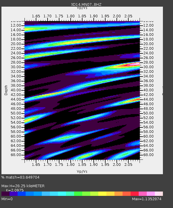
| Estimated Moho Depth: |
28.25 km |
| Estimated Crust Vp/Vs: |
2.10 |
| Assumed Crust Vp: |
6.566 km/s |
| Estimated Crust Vs: |
3.13 km/s |
| Estimated Crust Poisson's Ratio: |
0.35 |
|
| Radial Match: |
83.649704 % |
| Radial Bump: |
400 |
| Transverse Match: |
62.683292 % |
| Transverse Bump: |
400 |
| SOD ConfigId: |
7019011 |
| Insert Time: |
2019-04-17 07:06:56.254 +0000 |
| GWidth: |
2.5 |
| Max Bumps: |
400 |
| Tol: |
0.001 |
|

Signal To Noise
| Channel | StoN | STA | LTA |
| XD:MN07: :BHZ:20150310T21:04:45.670015Z | 14.818461 | 2.0770583E-6 | 1.4016693E-7 |
| XD:MN07: :BHN:20150310T21:04:45.670015Z | 1.1893417 | 5.0256455E-7 | 4.2255695E-7 |
| XD:MN07: :BHE:20150310T21:04:45.670015Z | 3.4727144 | 7.002291E-7 | 2.016374E-7 |
| Arrivals |
| Ps | 4.9 SECOND |
| PpPs | 13 SECOND |
| PsPs/PpSs | 18 SECOND |


