You are here: Home > Network List > II - Global Seismograph Network (GSN - IRIS/IDA) Stations List
> Station NIL Nilore, Pakistan > Earthquake Result Viewer
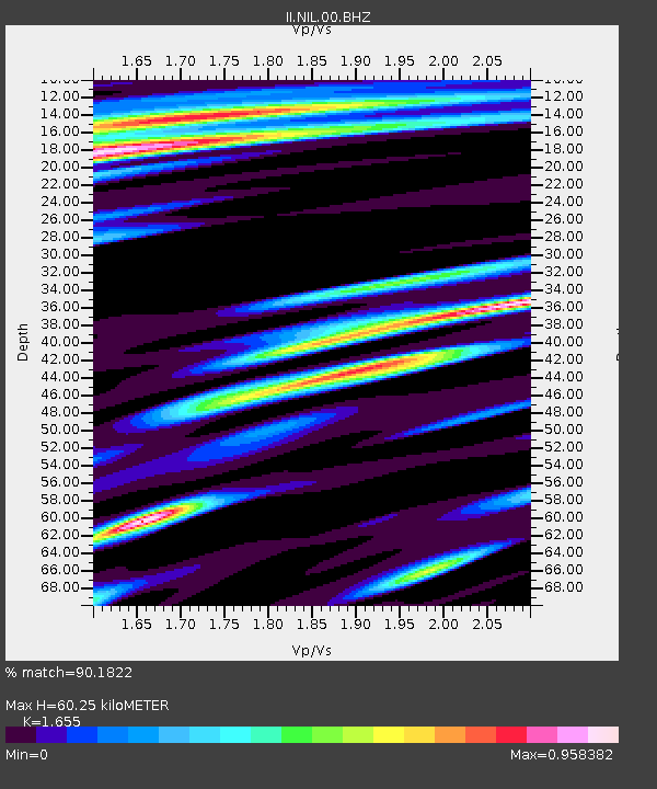
NIL Nilore, Pakistan - Earthquake Result Viewer
| Earthquake location: |
South Indian Ocean |
| Earthquake latitude/longitude: |
-10.1/91.1 |
| Earthquake time(UTC): |
2014/06/14 (165) 11:11:00 GMT |
| Earthquake Depth: |
7.1 km |
| Earthquake Magnitude: |
6.4 MWP, 6.4 MWB |
| Earthquake Catalog/Contributor: |
NEIC PDE/NEIC COMCAT |
|
| Network: |
II Global Seismograph Network (GSN - IRIS/IDA) |
| Station: |
NIL Nilore, Pakistan |
| Lat/Lon: |
33.65 N/73.27 E |
| Elevation: |
629 m |
|
| Distance: |
46.6 deg |
| Az: |
339.484 deg |
| Baz: |
155.558 deg |
| Ray Param: |
0.07052423 |
| Estimated Moho Depth: |
60.25 km |
| Estimated Crust Vp/Vs: |
1.65 |
| Assumed Crust Vp: |
6.242 km/s |
| Estimated Crust Vs: |
3.772 km/s |
| Estimated Crust Poisson's Ratio: |
0.21 |
|
| Radial Match: |
90.1822 % |
| Radial Bump: |
400 |
| Transverse Match: |
72.01437 % |
| Transverse Bump: |
400 |
| SOD ConfigId: |
739768 |
| Insert Time: |
2014-06-28 11:19:32.489 +0000 |
| GWidth: |
2.5 |
| Max Bumps: |
400 |
| Tol: |
0.001 |
|

Signal To Noise
| Channel | StoN | STA | LTA |
| II:NIL:00:BHZ:20140614T11:18:58.369004Z | 10.282682 | 9.3200316E-7 | 9.063814E-8 |
| II:NIL:00:BH1:20140614T11:18:58.369004Z | 1.4578811 | 2.7661113E-7 | 1.8973505E-7 |
| II:NIL:00:BH2:20140614T11:18:58.369004Z | 1.0327802 | 1.5355383E-7 | 1.4868006E-7 |
| Arrivals |
| Ps | 6.7 SECOND |
| PpPs | 24 SECOND |
| PsPs/PpSs | 31 SECOND |


